IMAGES TAKEN NEAR TO
Woodland Avenue, MANCHESTER, M18 7HF
Introduction
This page details the photographs taken nearby to Woodland Avenue, M18 7HF by members of the Geograph project.
The Geograph project started in 2005 with the aim of publishing, organising and preserving representative images for every square kilometre of Great Britain, Ireland and the Isle of Man.

There are currently over 7.5m images from over14,400 individuals and you can help contribute to the project by visiting https://www.geograph.org.uk
Image Map
Images are licensed for reuse under creativecommons.org/licenses/by-sa/2.0
Notes
- Clicking on the map will re-center to the selected point.
- The higher the marker number, the further away the image location is from the centre of the postcode.
Image Listing (234 Images Found)
Images are licensed for reuse under creativecommons.org/licenses/by-sa/2.0
Image
Details
Distance
1
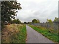
Footpath to Fairfield
Along the former Fairfield to Fallowfield railway.
Image: © Gerald England
Taken: 24 Sep 2009
0.03 miles
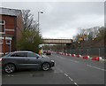
2
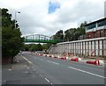
New bridge over Hyde Road
The old railway bridge Image which carries the Fallowfield Loop over Hyde Road has been replaced by a new bridge as part of the A57 Hyde Road Widening Scheme.
Image: © Gerald England
Taken: 7 Aug 2020
0.06 miles
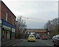
3
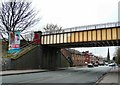
Hyde Road
The A57 into Manchester. The railway bridge carried a now abandoned freight line from Fairfield to Trafford Park that bypassed Piccadilly. In the distance is Brookfield Church Image
Image: © Gerald England
Taken: 25 Feb 2009
0.06 miles
4
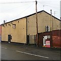
Gorton Working Men's Club
On Thornwood Avenue.
Image: © Gerald England
Taken: 17 Feb 2014
0.06 miles
5
A57 Hyde Road Widening Scheme
Work on the A57 Hyde Road Widening Scheme has meant the replacement of old railway bridge in the background Image used by cyclists and walkers on the Fallowfield Loop.with a new longer-span bridge.
Image: © Gerald England
Taken: 7 Aug 2020
0.06 miles
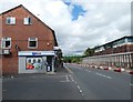
6
Golocal on Hyde Road
The former Bhatti Jee off-licence Image is now the Golocal Community Convenience Store. The new signage had just been erected. Meanwhile work has started on the A57 Hyde Road Widening Scheme. The old railway bridge in the background is due to be removed in a few days time. The bridge is used by cyclists and walkers on the Fallowfield Loop. It will be replaced a new longer-span bridge later in the year.
Image: © Gerald England
Taken: 18 Feb 2020
0.06 miles
7
Hyde Road
Work has started on the A57 Hyde Road Widening Scheme. The old railway bridge is due to be removed in a few days time. The bridge is used by cyclists and walkers on the Fallowfield Loop. It will be replaced by a new longer-span bridge later in the year.
Image: © Gerald England
Taken: 18 Feb 2020
0.06 miles
9
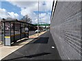
The widened Hyde Road
The A57 out of Manchester has been widened to allow two lanes of traffic in each direction approaching the junction with Reddish Lane. The work required the replacement of the old railway bridge Image with a wider-spanning footbridge. The new bridge carries the Fallowfield Loop, a footpath and cycle track using the route of a former railway.
Image: © Gerald England
Taken: 27 Mar 2021
0.06 miles
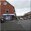
10
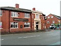
Friendship Tavern
Image: © Gerald England
Taken: 17 Feb 2014
0.07 miles