IMAGES TAKEN NEAR TO
Turnbull Road, MANCHESTER, M18 7AX
Introduction
This page details the photographs taken nearby to Turnbull Road, M18 7AX by members of the Geograph project.
The Geograph project started in 2005 with the aim of publishing, organising and preserving representative images for every square kilometre of Great Britain, Ireland and the Isle of Man.

There are currently over 7.5m images from over14,400 individuals and you can help contribute to the project by visiting https://www.geograph.org.uk
Image Map
Images are licensed for reuse under creativecommons.org/licenses/by-sa/2.0
Notes
- Clicking on the map will re-center to the selected point.
- The higher the marker number, the further away the image location is from the centre of the postcode.
Image Listing (127 Images Found)
Images are licensed for reuse under creativecommons.org/licenses/by-sa/2.0
Image
Details
Distance
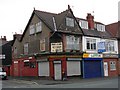
1
Essex Road
Taken from the older Essex Road side. Built on an old duck pond.
Image: © Peter Teal
Taken: 22 Feb 2010
0.02 miles
2
Mayfield Grove
Looking south, bollards at the end of grove.
Image: © Peter Teal
Taken: 22 Feb 2010
0.02 miles
3
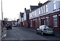
Ashfield Grove
Leading to Westbourne Range at the bottom.
Image: © Peter Teal
Taken: 22 Feb 2010
0.03 miles
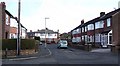
4
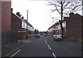
Turnbull Road
Leading to Brighton Range at the bottom. This first row of houses on the right have a beautiful combined Christmas show.
Image: © Peter Teal
Taken: 22 Feb 2010
0.05 miles
5
Westbourne Range
Taken from the A57 Hyde Road, leads down to Ashfield Grove.
Image: © Peter Teal
Taken: 24 Mar 2010
0.07 miles
6
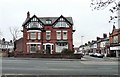
Home on the Range
A typical Victorian large house on Manchester Road, now converted into flats. The street on the right is Brighton Range and on the left is Westbourne Range.
Image: © Gerald England
Taken: 12 Feb 2009
0.07 miles
7
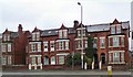
Hyde Road
These Victorian houses on Hyde Road near Debdale Park would once have each been home to a single large family. Most of them have now been converted into flats.
Image: © Gerald England
Taken: 26 Apr 2010
0.07 miles
8
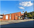
Aspinal Methodist Church
The Methodist Church in Reddish started with cottage meetings above the Aspinal Smithy at Brook Green Farm which was situated behind what is now the Bulls Head Hotel. In 1800 the Stockport Circuit took charge of the small enthusiastic society. The Church was registered in 1806 and the first Chapel opened in 1808. The original building soon became too small, and a scheme was launched in 1875 to remedy this, resulting in the building of a Chapel which cost £3000, this was large enough to hold 350 people. In 1907 a new Centenary Chapel opened which seated 850 people.
By the 1970s however it was becoming hard to maintain. The Sunday school was damaged by fire rendering it almost unusable so a decision was taken to sell part of the land and to rebuild the church as a multifunctional building.
In 1971 the foundation stone was laid for the new church, this stone having been taken from the base of the front from the 1910 building. The new church was designed by Mr. T. Howcroft and the built by William Thorpe.
It is part of the Hyde & Denton Methodist Circuit.
Image: © Gerald England
Taken: 30 Sep 2015
0.07 miles
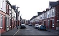
9
Gorton, Manchester
The junction of Turnbull Road and Reddish Lane, Gorton, Manchester. Just visible, attached to the chimney stack, is a "squariel", the squarish satellite tv dish used by the British Satellite Broadcasting Company before its merger with Sky(see supplemental). SJ89509550. See posts re. this photo in the grid square discussion - may not be a BSB dish!
Image: © Keith Williamson
Taken: 28 Sep 2005
0.08 miles
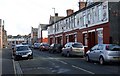
10
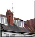
Squariel in Gorton
The "square" satellite dish as used by British Satellite Broadcasting before its merger with Sky. SJ89509550. (following grid sq discussion I now believe that this is a wireless broadband dish)
Image: © Keith Williamson
Taken: 28 Sep 2005
0.08 miles