IMAGES TAKEN NEAR TO
Demesne Road, MANCHESTER, M16 8PH
Introduction
This page details the photographs taken nearby to Demesne Road, M16 8PH by members of the Geograph project.
The Geograph project started in 2005 with the aim of publishing, organising and preserving representative images for every square kilometre of Great Britain, Ireland and the Isle of Man.

There are currently over 7.5m images from over14,400 individuals and you can help contribute to the project by visiting https://www.geograph.org.uk
Image Map
Images are licensed for reuse under creativecommons.org/licenses/by-sa/2.0
Notes
- Clicking on the map will re-center to the selected point.
- The higher the marker number, the further away the image location is from the centre of the postcode.
Image Listing (41 Images Found)
Images are licensed for reuse under creativecommons.org/licenses/by-sa/2.0
Image
Details
Distance
1
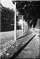
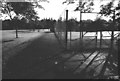
Demesne Road, Whalley Range, Alexandra Park, end of footpath, facing west
The strong early morning sunlight throws dramatic shadows across the sandstone flagstones. This part of Demesne Road had been fenced off, no doubt for some redevelopment work to take place.
Image: © Tom Jolliffe
Taken: Unknown
0.03 miles
2
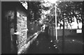
Public footpath, Demesne Road to Princess Road, Whalley Range/Moss Side
This footpath which joins Demesne Road to Princess Road and runs alongside Alexandra Park was under threat of closure in the earlier part of the 20th century. Local people fought a campaign to keep the footpath open and were successful. Had it been closed, a major detour to the south or to the north would have been needed for pedestrians when the park was locked up for the night. The grounds to the right were owned by the YMCA in the second half of the 20th century which had a major building nearby.
Image: © Tom Jolliffe
Taken: Unknown
0.03 miles
3
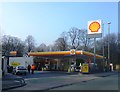
Fuel Filling Station - Alexandra Park
Image: © Anthony Parkes
Taken: 14 Mar 2012
0.07 miles
4
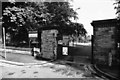
Alexandra Park entrance gates, Demesne Road, Whalley Range
The sign gives notice of an experimental cycle route through the park.
Image: © Tom Jolliffe
Taken: Unknown
0.11 miles
5
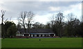
Tennis Courts, Alexandra Park, Moss side
These tennis courts are positioned opposite an old derelict cafeteria.
Image: © Tom Jolliffe
Taken: Unknown
0.11 miles
6
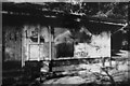
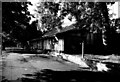
Derelict Cafeteria, Alexandra Park, Moss Side
This cafeteria is situated opposite some tennis courts. Once a cool retreat for the users of the park, paying witness in its design to a more genteel age, the structure had been abandoned to the ravages of the weather, nature and local teenagers. Extraordinary though it may seem, a bull used to be kept behind this cafeteria, with a ring in its nose. This was a fearsome sight for young children and I cannot account for this. Someone loved "Chantelle 97"? Taken at 8 a.m.
Image: © Tom Jolliffe
Taken: Unknown
0.11 miles
8
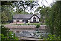
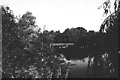
The Pavilion in Alexandra Park
Looking across the lake
Image: © Glyn Baker
Taken: 1 Sep 2018
0.11 miles
9
Derelict Cafeteria, Alexandra park, Moss Side
The sorry state of the old cafeteria, with its wrought iron supports, seems more pronounced in the quiet sunlight of the early morning.
Image: © Tom Jolliffe
Taken: Unknown
0.12 miles
10
Alexandra Park Lake, Moss Side
The ornamental lake in Alexandra Park always had a population of ducks and swans. It is also used by fishing enthusiasts, who probably exercise some control over the potential excesses of deliquents.
Image: © Tom Jolliffe
Taken: Unknown
0.14 miles