IMAGES TAKEN NEAR TO
Withington Road, MANCHESTER, M16 8JL
Introduction
This page details the photographs taken nearby to Withington Road, M16 8JL by members of the Geograph project.
The Geograph project started in 2005 with the aim of publishing, organising and preserving representative images for every square kilometre of Great Britain, Ireland and the Isle of Man.

There are currently over 7.5m images from over14,400 individuals and you can help contribute to the project by visiting https://www.geograph.org.uk
Image Map
Images are licensed for reuse under creativecommons.org/licenses/by-sa/2.0
Notes
- Clicking on the map will re-center to the selected point.
- The higher the marker number, the further away the image location is from the centre of the postcode.
Image Listing (19 Images Found)
Images are licensed for reuse under creativecommons.org/licenses/by-sa/2.0
Image
Details
Distance
1
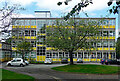
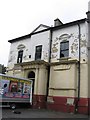
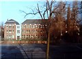
School, Withington Road, Manchester
A well-preserved 1960s building.
Now St Margaret's Church of England Primary School.
Image: © Stephen Richards
Taken: 17 Aug 2016
0.10 miles
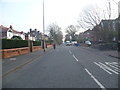
3
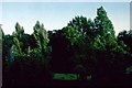
Garden, Wellington Road, Whalley Range, Manchester
These private gardens have now been landscaped and the trees no longer exist. The road in the background is Stanley Road. The high wall at the end of the garden is the boundary for the Cenacle Convent's grounds.
Image: © Tom Jolliffe
Taken: Unknown
0.17 miles
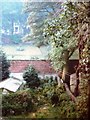
4
Cenacle Convent grounds, Whalley Range, Manchester
The grounds of the Cenacle Convent as they were in 1982. The house in the picture was on the other side of Stanley Road. These grounds have now been used for a housing development. Also see Image] Image] Image] Image]
Image: © Tom Jolliffe
Taken: Unknown
0.17 miles
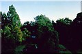
5
Cenacle Convent grounds, Whalley Range, Manchester
This photograph shows the grounds of the Cenacle Convent in 1982. The Retreat House is shown on the left hand side.
Image: © Tom Jolliffe
Taken: Unknown
0.17 miles
6
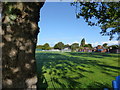
St Bede's College Playing Field, Withington Road
The playing field has been used for St Bede's College pupils for perhaps 100 years. The Pavilion is at the far side of the field.
Image: © Tom Jolliffe
Taken: 30 Sep 2016
0.18 miles
7
Sunnyside Villa, 52 College Road, Whalley Range, Manchester
This is Sunnyside Villa, Whalley Range, built in 1858 and now one of the last couple of original villas in the area dating from Samuel Brooks layout of Whalley Range. The building with extensive servants quarters hasn’t been lived in for over 40 years and is now under threat from demolition.
**UPDATE MARCH 2009** Sunnyside Villa was demolished in March 2009 to build over 20 terraced houses. Thanks to Jim Thornbury of Range Warehouses
Image: © Ian
Taken: Unknown
0.19 miles
8
Sunnyside Villa, 52 College Road, Whalley Range, Manchester
This is the entrance gates to Sunnyside Villa, Whalley Range, built in 1858 and now one of the last couple of original villas in the area dating from Samuel Brooks layout of Whalley Range. The building with extensive servants quarters hasn’t been lived in for over 40 years and is now under threat from demolition
**UPDATE MARCH 2009** Sunnyside Villa was demolished in March 2009 to build over 20 terraced houses. Thanks to Jim Thornbury of Range Warehouses. This lovely boundary wall, of solide yellow sandstone with the inscription "SUNNYSIDE" carved in it has been terribly mutalated by the contractors
Image: © Ian
Taken: Unknown
0.20 miles
9
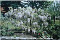
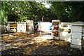
Wisteria bush, garden, Wellington Road, Whalley Range
This wisteria appeared to thrive on this fence at the rear of 7 Wellington Road. On the left can be seen part of the St Regis building, which had been taken over from the Cenacle Convent by St Bede's College.
Image: © Tom Jolliffe
Taken: Unknown
0.20 miles
10
St Bede's College, Whalley Range, Manchester
This building, part of St Bede's College, is called the Henshaw building. This was constructed circa 1930s and housed Science laboratories.
Image: © Tom Jolliffe
Taken: 25 Dec 1969
0.21 miles