IMAGES TAKEN NEAR TO
Wilbraham Road, MANCHESTER, M16 8GN
Introduction
This page details the photographs taken nearby to Wilbraham Road, M16 8GN by members of the Geograph project.
The Geograph project started in 2005 with the aim of publishing, organising and preserving representative images for every square kilometre of Great Britain, Ireland and the Isle of Man.

There are currently over 7.5m images from over14,400 individuals and you can help contribute to the project by visiting https://www.geograph.org.uk
Image Map
Images are licensed for reuse under creativecommons.org/licenses/by-sa/2.0
Notes
- Clicking on the map will re-center to the selected point.
- The higher the marker number, the further away the image location is from the centre of the postcode.
Image Listing (19 Images Found)
Images are licensed for reuse under creativecommons.org/licenses/by-sa/2.0
Image
Details
Distance
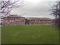
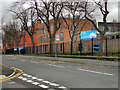
2
Whalley Range Girls High School
Situated on the junction of Wilbraham Road and Princess Road, Whalley Range Girls High School serves the Manchester areas of Whalley Range and Moss Side.
Image: © R Greenhalgh
Taken: 7 Mar 2008
0.08 miles
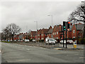
4
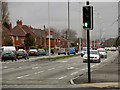
Princess Road, Manchester
Travelling north towards Manchester, approaching the junction of Princess Road with Wilbraham Road.
Image: © Tricia Neal
Taken: 13 Apr 2014
0.08 miles
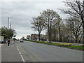
6
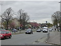
The A5103 Princess Road at Whalley Range
Looking north.
Image: © Rod Allday
Taken: 12 Apr 2014
0.11 miles
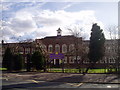
9
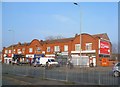
William Hulme's Grammar School
William Hulme's Grammar School, Spring Bridge Road
Image: © David Dixon
Taken: 7 Jan 2012
0.13 miles
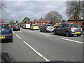
10
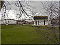
The A5103 Princess Road at Whalley Range
Looking south.
Image: © Rod Allday
Taken: 12 Apr 2014
0.16 miles