IMAGES TAKEN NEAR TO
Chester Road, MANCHESTER, M16 0QW
Introduction
This page details the photographs taken nearby to Chester Road, M16 0QW by members of the Geograph project.
The Geograph project started in 2005 with the aim of publishing, organising and preserving representative images for every square kilometre of Great Britain, Ireland and the Isle of Man.

There are currently over 7.5m images from over14,400 individuals and you can help contribute to the project by visiting https://www.geograph.org.uk
Image Map (Loading...)


Getting Data...Please wait
Leaflet Map data © OpenStreetMap
Images are licensed for reuse under creativecommons.org/licenses/by-sa/2.0
Notes
- Clicking on the map will re-center to the selected point.
- The higher the marker number, the further away the image location is from the centre of the postcode.
Image Listing (140 Images Found)
Images are licensed for reuse under creativecommons.org/licenses/by-sa/2.0
Image
Details
Distance
2
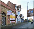
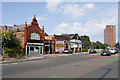
Chester Road, Old Trafford
The Old Trafford branch of Martins Bank at 555 Chester Road was opened in 1899 as the Lancashire and Yorkshire Bank Ltd. It became a Martins Bank in 1928 and a branch of Barclays in 1969. It was closed in June 1992 after "one too many armed hold-ups" http://www.martinsbank.co.uk/11-61-60%20Manchester%20Old%20Trafford.htm Originally the bank had a second entrance on Talbot Road but that was closed in the 1980s as it was being used as a thoroughfare.
Image: © Gerald England
Taken: 13 Feb 2017
0.01 miles
3
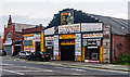
Tommy's
Tommy's "World Famous House of Fires" on Talbot Road.
Image: © Peter McDermott
Taken: 19 Jul 2014
0.02 miles
4
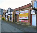
##2-8 Talbot Road, Old Trafford
#2 Talbot Road (rear of 553 Chester Road) was Tommys fireplace showroom which has been closed down for many years,
#4 Talbot Road is the back of Martins Bank Image The entrance was closed in the 1980s as it was being used as a thoroughfare. The bank closed in June 1992 after "one too many armed hold-ups" http://www.martinsbank.co.uk/11-61-60%20Manchester%20Old%20Trafford.htm
#6 Talbot Road is Tony's barber shop.
#8 Talbot Road is a two storey building. The ground floor and basement are currently used as offices and storage space and are let to tenants. The first floor is let as separate offices with its own entrance. At the time this photograph was taken it was "For Let".
Image: © Gerald England
Taken: 13 Feb 2017
0.02 miles
5
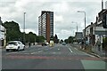
Old Trafford, Talbot Road
A5104 towards the city centre.
Image: © David Dixon
Taken: 14 Aug 2020
0.02 miles
6
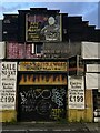
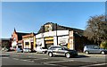
Abandoned fireplace shop
Abandoned derelict shop, Old Trafford.
Image: © Paul Foster
Taken: 11 May 2023
0.02 miles
7
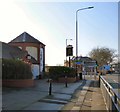
The Tollgate
A Marstons pub on the corner of Talbot Road and Seymour Road. In the background behind the signs Image is the former Trafford Bar station now a tram stop.
Image: © Gerald England
Taken: 13 Feb 2017
0.03 miles
9
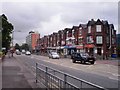
Seymour Grove, Manchester
Shops on Seymour Grove, near the junction with Talbot Road
Image: © Duncan Watts
Taken: 26 May 2011
0.03 miles
10
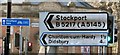
Signage at Trafford Bar
Various signage at Trafford Bar including "Railway Station" etched in stone on the former station on Seymour Street now a tram stop, direction signs for the B5217 which at Chorlton-cum-Hardy becomes the A5145 to Didsbury and Stockport, and a cycle route sign pointing to Stretford and Sale.
Image: © Gerald England
Taken: 13 Feb 2017
0.04 miles