IMAGES TAKEN NEAR TO
Millbeck Street, MANCHESTER, M15 6TB
Introduction
This page details the photographs taken nearby to Millbeck Street, M15 6TB by members of the Geograph project.
The Geograph project started in 2005 with the aim of publishing, organising and preserving representative images for every square kilometre of Great Britain, Ireland and the Isle of Man.

There are currently over 7.5m images from over14,400 individuals and you can help contribute to the project by visiting https://www.geograph.org.uk
Image Map
Images are licensed for reuse under creativecommons.org/licenses/by-sa/2.0
Notes
- Clicking on the map will re-center to the selected point.
- The higher the marker number, the further away the image location is from the centre of the postcode.
Image Listing (126 Images Found)
Images are licensed for reuse under creativecommons.org/licenses/by-sa/2.0
Image
Details
Distance
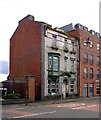
1
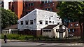
The Gamecock
The pub opened in 1974 as a Wilson's House but soon changed to Watney's. It stands in the shadow of some of Hulme's surviving flats on the corner of Boundary Lane and Booth Street West. Having stood empty for a long time it seemed quite likely to be demolished to make room for yet more student accommodation. http://pubs-of-manchester.blogspot.co.uk/2011/06/gamecock-boundary-lane.html
In 1993 it was a Belhaven Brewery tied house. http://www.closedpubs.co.uk/lancashire/manchester_m15_gamecock.html but by the time of its closure it was Tetley's house. http://manchesterhistory.net/manchester/pubs/gamecock.html
An application for student accommodation on the site was turned down in 2012 on the grounds that the development would be out of scale with the two-storey residential houses nearby, would block out sunlight and there was also a lack of adequate parking. http://www.manchestereveningnews.co.uk/news/greater-manchester-news/application-to-build-giant-block-of-students-693402
Image: © Gerald England
Taken: 13 May 2017
0.05 miles
2
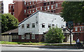
The Gamecock, Boundary Lane, Manchester
Probably a former estate pub, not especially interesting to the casual observer, but possessing a certain nostalgia value for me and so I'm sorry to see it fall on hard times. While a student in Manchester living in a nearby hall of residence, Cornbrook House, a few of us made this pub a reasonably regular haunt. We would often play darts. This was in 1987/88 and people would have you believe that in the bad old days of Hulme, before the crescents were pulled down, it wouldn't have been possible for a group of students to enter a locals' pub like this and emerge with their limbs intact. However, there was never a sniff of trouble.
Update and more info: Image
Image: © Stephen Richards
Taken: 23 Jul 2011
0.06 miles
3
The Gamecock
The Gamecock public house.
Image: © Peter McDermott
Taken: 4 Jul 2015
0.06 miles
4
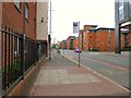
Higher Cambridge Street
Bus stop near Boundary Street West and Cavendish Street.
Image: © Gerald England
Taken: 13 May 2017
0.09 miles
5
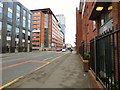
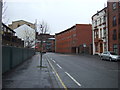
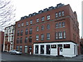
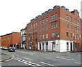
Higher Cambridge Street
The large red building on the left labelled "Liberty Living" is given over to student accommodation.
Image: © Gerald England
Taken: 13 May 2017
0.09 miles
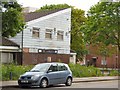
7
Korean restaurant and apartments
On Wilmott Street.
Image: © JThomas
Taken: 9 Mar 2013
0.10 miles
8
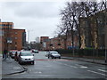
Student accommodation, Stretford Road (A5067), Hulme
Image: © habiloid
Taken: 27 Jul 2007
0.10 miles