IMAGES TAKEN NEAR TO
Higher Cambridge Street, MANCHESTER, M15 6HP
Introduction
This page details the photographs taken nearby to Higher Cambridge Street, M15 6HP by members of the Geograph project.
The Geograph project started in 2005 with the aim of publishing, organising and preserving representative images for every square kilometre of Great Britain, Ireland and the Isle of Man.

There are currently over 7.5m images from over14,400 individuals and you can help contribute to the project by visiting https://www.geograph.org.uk
Image Map
Images are licensed for reuse under creativecommons.org/licenses/by-sa/2.0
Notes
- Clicking on the map will re-center to the selected point.
- The higher the marker number, the further away the image location is from the centre of the postcode.
Image Listing (105 Images Found)
Images are licensed for reuse under creativecommons.org/licenses/by-sa/2.0
Image
Details
Distance
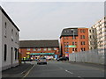
2
Greenheys, high school
Trinity CoE High School, on Higher Cambridge Street: https://www.trinityhigh.com/about-us/
Image: © Mike Faherty
Taken: 7 Feb 2019
0.07 miles
3
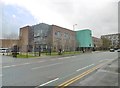
Trinity C of E High School
The school was formed in 1984 as a merger of Bishop Greer and Fallowfield schools. The new building fronting Higher Cambridge Street opened in 2014.
Image: © Gerald England
Taken: 1 Sep 2018
0.08 miles
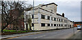
4
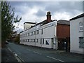
McDougall Centre
Former drill hall dating from 1885 with 1939 modifications to facade. The original buildings can just be seen.
More recently used as a sports centre.
Image: © John M
Taken: 20 Oct 2014
0.08 miles
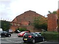
6
McDougall Centre
Former drill hall dating from 1885 on Burlington Street.
Image: © Peter McDermott
Taken: 31 Jan 2021
0.09 miles
7
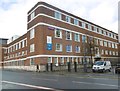
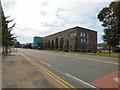
Greenheys, dental hospital
University Dental Hospital of Manchester, on Higher Cambridge Street: https://mft.nhs.uk/dental/about/
Image: © Mike Faherty
Taken: 7 Feb 2019
0.09 miles
8
Side view McDougall Centre
The large drill hall was originally built in 1885 and extended in 1939. The original section appears to the right of the photo with extension to left.
Image: © John M
Taken: 20 Oct 2014
0.10 miles
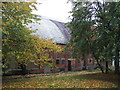
9
Rear of McDougall Centre
Former Drill Hall and Sports Centre on Burlington Street. Unclear whether this is part of the original 1885 building or an extension in matching style in 1939.
Image: © John M
Taken: 20 Oct 2014
0.12 miles
10
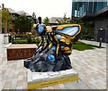
BZZX!!
Located outside the Bright Building at Manchester Science Park, Lloyd Street this Bee was created by KrikSix in collaboration with Jason Heppenstall and sponsored by Manchester Science Partnerships.
"Manchester Science Partnerships (MSP) is a partnership between Manchester's universities, NHS, councils and private sector which have come together to create the UK's leading science and technology park operator. Providing the home to more than 300 science & tech businesses, MSP provides specialist growth support to life sciences, digital technology and advanced engineering businesses – from start-ups to international centres of R&D excellence."
Image: © Gerald England
Taken: 22 Sep 2018
0.13 miles