IMAGES TAKEN NEAR TO
Bonsall Street, MANCHESTER, M15 6GU
Introduction
This page details the photographs taken nearby to Bonsall Street, M15 6GU by members of the Geograph project.
The Geograph project started in 2005 with the aim of publishing, organising and preserving representative images for every square kilometre of Great Britain, Ireland and the Isle of Man.

There are currently over 7.5m images from over14,400 individuals and you can help contribute to the project by visiting https://www.geograph.org.uk
Image Map
Images are licensed for reuse under creativecommons.org/licenses/by-sa/2.0
Notes
- Clicking on the map will re-center to the selected point.
- The higher the marker number, the further away the image location is from the centre of the postcode.
Image Listing (73 Images Found)
Images are licensed for reuse under creativecommons.org/licenses/by-sa/2.0
Image
Details
Distance
1
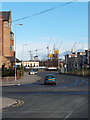
Work In Progress
Taken from Hulme High Street at its junction with Old Birley Street and Greenheys Lane West this image shows various high level construction sites. These buildings, including the landmark Hilton/Beetham Tower, have now been completed.
Image: © Marcus Hargis
Taken: 13 Feb 2005
0.01 miles
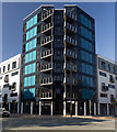
2
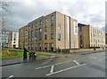
Hulme, Dale
One of several similar accommodation blocks for Manchester Metropolitan University; this one is on Chichester Road.
Image: © Mike Faherty
Taken: 7 Feb 2019
0.02 miles
3
Ormsgill Close, Hulme
On the left is the 'Homes for Change' building - a housing co-operative. Beyond that is The Junction public house on Old Birley Street/Rolls Crescent.
Image: © Marcus Hargis
Taken: 5 Feb 2007
0.04 miles
5
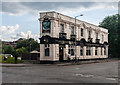
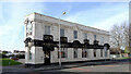
The Junction Hotel
The Junction Hotel public house in Hulme.
Image: © Peter McDermott
Taken: 28 Jul 2014
0.06 miles
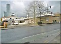
6
Stretford Road
Building on Stretford Road.
Image: © Peter McDermott
Taken: 15 Jul 2018
0.06 miles
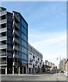
7

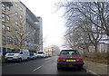
Manchester Metropolitan University
New building for Manchester Metropolitan University.
Image: © Peter McDermott
Taken: 15 Feb 2015
0.07 miles
8
Stretford Road (A5067) at its junction with Royce Road, Hulme
Image: © habiloid
Taken: 6 May 2013
0.07 miles
9
Hulme, Ascension Church
Church of England church on Stretford Road: https://www.manchester.anglican.org/acny/church/402/
Image: © Mike Faherty
Taken: 7 Feb 2019
0.08 miles
10
Archway in Hulme
The road, called Archway, looks towards the footbridge to the Aquarius Estate and to the Hulme Arch.
Image: © Marcus Hargis
Taken: 5 Feb 2007
0.10 miles