IMAGES TAKEN NEAR TO
George Parr Road, MANCHESTER, M15 6GS
Introduction
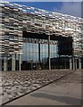
This page details the photographs taken nearby to George Parr Road, M15 6GS by members of the Geograph project.
The Geograph project started in 2005 with the aim of publishing, organising and preserving representative images for every square kilometre of Great Britain, Ireland and the Isle of Man.

There are currently over 7.5m images from over14,400 individuals and you can help contribute to the project by visiting https://www.geograph.org.uk
Image Map
Images are licensed for reuse under creativecommons.org/licenses/by-sa/2.0
Notes
- Clicking on the map will re-center to the selected point.
- The higher the marker number, the further away the image location is from the centre of the postcode.
Image Listing (76 Images Found)
Images are licensed for reuse under creativecommons.org/licenses/by-sa/2.0
Image
Details
Distance
1
Archway in Hulme
The road, called Archway, looks towards the footbridge to the Aquarius Estate and to the Hulme Arch.
Image: © Marcus Hargis
Taken: 5 Feb 2007
0.04 miles
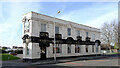
2
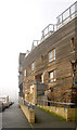
The 'Homes for Change' Building
'Homes for Change' is a co-operative that operates this multi-use building containing residential and small-scale commercial premises.
Image: © Marcus Hargis
Taken: 5 Feb 2007
0.05 miles
3
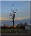
Sunset in the East?
A setting sun reflected in a modern building taken from Birley Fields Manchester.
Image: © Steve Fareham
Taken: 20 Jan 2009
0.06 miles
4
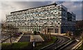
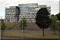
Manchester Metropolitan University
New building for Manchester Metropolitan University.
Image: © Peter McDermott
Taken: 15 Feb 2015
0.07 miles
5
Manchester Metropolitan University
New building for Manchester Metropolitan University.
Image: © Peter McDermott
Taken: 15 Feb 2015
0.07 miles
6
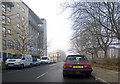
Ormsgill Close, Hulme
On the left is the 'Homes for Change' building - a housing co-operative. Beyond that is The Junction public house on Old Birley Street/Rolls Crescent.
Image: © Marcus Hargis
Taken: 5 Feb 2007
0.07 miles
7
Ormsgill Street, Hulme
The 'Homes for Change' building is on the right.
Image: © Marcus Hargis
Taken: 5 Feb 2007
0.08 miles
8
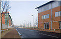
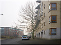
Birley Fields Campus, Manchester Metropolitan University
The campus, in Hulme, is seen here from Birchall Way on the other side of Princess Road (A5103).
Image: © habiloid
Taken: 29 Jun 2014
0.08 miles
10
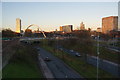
Princess Parkway, Manchester
The main route south to the M6 from Manchester city centre, the A5103. Many of the features of the city centre are visible ahead.
Image: © Bill Boaden
Taken: 1 Dec 2012
0.09 miles