IMAGES TAKEN NEAR TO
Bold Street, MANCHESTER, M15 5QR
Introduction
This page details the photographs taken nearby to Bold Street, M15 5QR by members of the Geograph project.
The Geograph project started in 2005 with the aim of publishing, organising and preserving representative images for every square kilometre of Great Britain, Ireland and the Isle of Man.

There are currently over 7.5m images from over14,400 individuals and you can help contribute to the project by visiting https://www.geograph.org.uk
Image Map
Images are licensed for reuse under creativecommons.org/licenses/by-sa/2.0
Notes
- Clicking on the map will re-center to the selected point.
- The higher the marker number, the further away the image location is from the centre of the postcode.
Image Listing (61 Images Found)
Images are licensed for reuse under creativecommons.org/licenses/by-sa/2.0
Image
Details
Distance
1
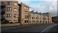
Modern apartment block in Chichester Road South
Image: © David Martin
Taken: 16 Feb 2017
0.02 miles
2
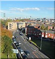
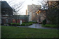
Greenheys Lane West from Loreto College
Image: © Anthony Parkes
Taken: 21 Oct 2012
0.05 miles
3
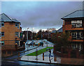
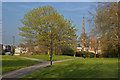
Hulme View
Taken from the junction on Greenheys Lane West (in the foreground) and Mytton Street, looking at the cut-through leading to Sam Swire Street. In the mid-ground are housing association properties.In the background, Manchester Corporation housing can just be seen.
Image: © Marcus Hargis
Taken: 6 Dec 2006
0.06 miles
4
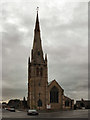
St Mary's Church, Hulme
Grade II listed building, now converted into apartments.
Image: © David Dixon
Taken: 13 Jul 2010
0.08 miles
6
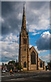
St Mary's Church
St Mary's Church in Hulme, Manchester.
Image: © Peter McDermott
Taken: 28 Jul 2014
0.09 miles
7
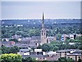
St Mary's Church, Hulme
The spire of St Mary's is still a prominent landmark on the South Manchester skyline even though it is no longer used as a church. See Image] for a ground level view.
Image: © David Dixon
Taken: 4 Jul 2014
0.09 miles
8
Loreto 6th Form College
Well-known RC college.
Image: © Bill Boaden
Taken: 1 Dec 2012
0.09 miles
9
Junctions
Taken from Blanchard Street, towards the junction of Old Birley Street, Greenheys Lane West and Hulme High Street. The building under construction is the 'pork pie' round block of flats, now completed.
Image: © Marcus Hargis
Taken: 13 Feb 2005
0.09 miles