IMAGES TAKEN NEAR TO
Alanbrooke Walk, MANCHESTER, M15 5EN
Introduction
This page details the photographs taken nearby to Alanbrooke Walk, M15 5EN by members of the Geograph project.
The Geograph project started in 2005 with the aim of publishing, organising and preserving representative images for every square kilometre of Great Britain, Ireland and the Isle of Man.

There are currently over 7.5m images from over14,400 individuals and you can help contribute to the project by visiting https://www.geograph.org.uk
Image Map
Images are licensed for reuse under creativecommons.org/licenses/by-sa/2.0
Notes
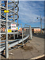
- Clicking on the map will re-center to the selected point.
- The higher the marker number, the further away the image location is from the centre of the postcode.
Image Listing (66 Images Found)
Images are licensed for reuse under creativecommons.org/licenses/by-sa/2.0
Image
Details
Distance
1
Hulme View
Taken from the junction on Greenheys Lane West (in the foreground) and Mytton Street, looking at the cut-through leading to Sam Swire Street. In the mid-ground are housing association properties.In the background, Manchester Corporation housing can just be seen.
Image: © Marcus Hargis
Taken: 6 Dec 2006
0.05 miles
2
Old Hulme Playhouse
The old Hulme Playhouse theatre currently being used as a community arts hub called the Nia Centre. Photo taken on a day when an exhibition celebrating the 40th anniversary of the Anti Nazi League's Northern Carnival Against the Nazis was on.
Image: © habiloid
Taken: 8 Sep 2018
0.07 miles
4
Old BBC Playhouse
Formerly a cinema. This image taken from Phoenix Way looking towards the junction with Old Birley Street and Chichester Road.
Image: © Marcus Hargis
Taken: 5 Feb 2007
0.08 miles
5
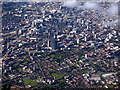
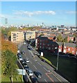
Manchester from the air
Looking over Hulme towards the city centre from above Northenden (4 miles south) from a Prague bound flight from Manchester. The A57(M) road marks the clear boundary between city and suburb.
Image: © Thomas Nugent
Taken: 6 Jul 2020
0.10 miles
6
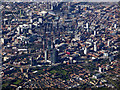
Manchester from the air
Looking over Hulme towards the city centre from above Northenden (4 miles south) from a Prague bound flight from Manchester. The A57(M) road marks the clear boundary between city and suburb.
Image: © Thomas Nugent
Taken: 6 Jul 2020
0.10 miles
7
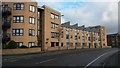
Modern apartment block in Chichester Road South
Image: © David Martin
Taken: 16 Feb 2017
0.10 miles
8
Life Buildings Tower
Taken from the ASDA Car Park. This particular view is no longer possible due to further development where the foreground is in the image.
Image: © Marcus Hargis
Taken: 26 Sep 2004
0.12 miles
9
Junctions
Taken from Blanchard Street, towards the junction of Old Birley Street, Greenheys Lane West and Hulme High Street. The building under construction is the 'pork pie' round block of flats, now completed.
Image: © Marcus Hargis
Taken: 13 Feb 2005
0.12 miles
10
Greenheys Lane West from Loreto College
Image: © Anthony Parkes
Taken: 21 Oct 2012
0.14 miles