IMAGES TAKEN NEAR TO
Trentham Street, MANCHESTER, M15 4YE
Introduction
This page details the photographs taken nearby to Trentham Street, M15 4YE by members of the Geograph project.
The Geograph project started in 2005 with the aim of publishing, organising and preserving representative images for every square kilometre of Great Britain, Ireland and the Isle of Man.

There are currently over 7.5m images from over14,400 individuals and you can help contribute to the project by visiting https://www.geograph.org.uk
Image Map
Images are licensed for reuse under creativecommons.org/licenses/by-sa/2.0
Notes
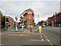
- Clicking on the map will re-center to the selected point.
- The higher the marker number, the further away the image location is from the centre of the postcode.
Image Listing (216 Images Found)
Images are licensed for reuse under creativecommons.org/licenses/by-sa/2.0
Image
Details
Distance
1
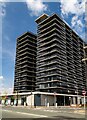
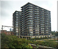
Vox
New residential development. See also Image
Image: © Peter McDermott
Taken: 2 May 2021
0.01 miles
2
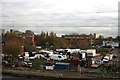
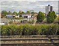
Manchester: View from Cornbrook Metrolink station
If travelling by Metrolink from Manchester City Centre to the Airport, one has to change cars at Cornbrook. Here is your view southeast from the station. I don't suppose this view will figure in the city's Welcome brochure for 2015...
Image: © Dr Neil Clifton
Taken: 4 Nov 2014
0.01 miles
3
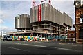
Chester Road
Development alongside Chester Road.
Image: © Peter McDermott
Taken: 21 Jul 2019
0.02 miles
4
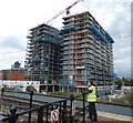
Construction work near Cornbrook
Viewed from the tram stop.
Image: © Gerald England
Taken: 21 Jul 2020
0.02 miles
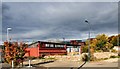
5
More development
Runcorn Street, Cornbrook: not the most elegant of buildings!
Image: © Anthony O'Neil
Taken: 20 Sep 2024
0.02 miles
6
J D Motor Services
Westminster Street, Cornbrook.
Image: © Gerald England
Taken: 17 Oct 2015
0.02 miles
7
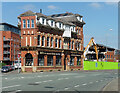
Former pub, Chester Road, Manchester
The ex-Turville. A slightly odd looking building with its top-heaviness. Grade II listed.
Now home to Insitu, architectural salvage merchants. It seems unlikely that anything being pulled down beyond found its way next door. A few years later the demolition site looked like this Image
Image: © Stephen Richards
Taken: 17 Aug 2016
0.03 miles
8
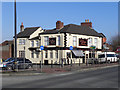
Pomona Palace
The Pomona Palace, a public house on Chester Road. The name relates to the nearby Pomona Docks.
Image: © David Dixon
Taken: 1 Feb 2012
0.03 miles
9
Chester Road, St Georges
The A56 into Manchester. The former Turville Public House on the corner of Ellesmere Street and Chester Road is a Grade II listed building http://www.britishlistedbuildings.co.uk/en-388008-turville-public-house- It dates back to the 1870s and was granted a spirits licence in 1896. It was originally the Commercial Hotel. later becoming the Turville and then the Last Hop. http://pubs-of-manchester.blogspot.co.uk/2011/03/turville-commercial-hotel-chester-road.html It is now home to Insitu Architectural Salvage http://www.insitumanchester.com/about-us/
Image: © Gerald England
Taken: 17 Oct 2015
0.03 miles
10
Dinton Street
View from a Metrolink tram across the railway line and the remains of Dinton Street (largely demolished) towards Chester Road.
Image: © Gerald England
Taken: 1 Jun 2013
0.03 miles