IMAGES TAKEN NEAR TO
Slate Wharf, MANCHESTER, M15 4SX
Introduction
This page details the photographs taken nearby to Slate Wharf, M15 4SX by members of the Geograph project.
The Geograph project started in 2005 with the aim of publishing, organising and preserving representative images for every square kilometre of Great Britain, Ireland and the Isle of Man.

There are currently over 7.5m images from over14,400 individuals and you can help contribute to the project by visiting https://www.geograph.org.uk
Image Map
Images are licensed for reuse under creativecommons.org/licenses/by-sa/2.0
Notes
- Clicking on the map will re-center to the selected point.
- The higher the marker number, the further away the image location is from the centre of the postcode.
Image Listing (1050 Images Found)
Images are licensed for reuse under creativecommons.org/licenses/by-sa/2.0
Image
Details
Distance
1
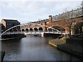
Footbridge, canals and Railway viaduct
Castlefields, Manchester.
Image: © SMJ
Taken: 21 Jan 2009
0.01 miles
2
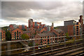
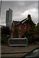
Inner city living
In the last 15 years, people have taken up residence near Manchester city centre again after a century of drift to the suburbs.
Image: © Anthony O'Neil
Taken: 27 Sep 2014
0.01 miles
3
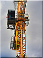
High Rise Crane at Castlefield
Signs of yet-more development in the area next to the Wharf public house at Castlefield Basin.
https://www.placenorthwest.co.uk/news/castlefield-residential-scheme-revived/ Place North West
Image: © David Dixon
Taken: 7 Mar 2022
0.02 miles
4

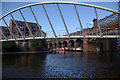
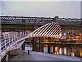
The Merchant's Bridge at Castlefield
This spectacular footbridge was built from Slate Wharf to Catalan Square during the regeneration of the Castlefield basin. Merchant's Bridge has a span of 40 metres and the 3-metre wide deck is hung by 13 hangers from the steel arches.
The viaduct in the background is one of three nineteenth century viaducts crossing the Castlefield Basin.
Image: © David Dixon
Taken: 1 Feb 2012
0.02 miles
5
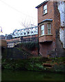
Canal-side building
At lock 92 at the end of the Rochdale canal.
Image: © Thomas Nugent
Taken: 28 Feb 2011
0.02 miles
7
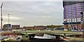
Dockland transformation
Manchester is being transformed with new building all around. The old docks may see no ships, but there's reason behind the term 'Northern Powerhouse' in these parts.
Image: © Chris Morgan
Taken: 23 Oct 2015
0.02 miles
8
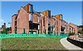
Slate Wharf, Castlefield
A new development of 24 apartments in Castlefield.
Image: © Peter McDermott
Taken: 9 Jul 2023
0.02 miles
9
Castlefield Basin
At Castlefield the Bridgewater and Rochdale canals meet in an area with extensive visitor moorings - generally considered the best in central Manchester. The junction is crossed by the modern - and controversial - Merchants Footbridge.
Image: © Stephen McKay
Taken: 30 Aug 2010
0.02 miles
10
The Merchant's Bridge at Castlefield
This spectacular modern footbridge crosses the Bridgewater Canal from Slate Wharf to Catalan Square. It was erected when Castlefield was redeveloped from an industrial to a residential area. Merchant's Bridge has a span of 40 metres and the 3-metre wide deck is hung by 13 hangers from the steel arches.
This view is from Slate Wharf. The viaduct in the background is one of three nineteenth century railway viaducts crossing the Castlefield Basin.
Image: © David Dixon
Taken: 10 Jan 2013
0.02 miles