IMAGES TAKEN NEAR TO
Slate Wharf, MANCHESTER, M15 4ST
Introduction
This page details the photographs taken nearby to Slate Wharf, M15 4ST by members of the Geograph project.
The Geograph project started in 2005 with the aim of publishing, organising and preserving representative images for every square kilometre of Great Britain, Ireland and the Isle of Man.

There are currently over 7.5m images from over14,400 individuals and you can help contribute to the project by visiting https://www.geograph.org.uk
Image Map
Images are licensed for reuse under creativecommons.org/licenses/by-sa/2.0
Notes
- Clicking on the map will re-center to the selected point.
- The higher the marker number, the further away the image location is from the centre of the postcode.
Image Listing (1042 Images Found)
Images are licensed for reuse under creativecommons.org/licenses/by-sa/2.0
Image
Details
Distance
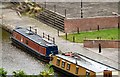
1
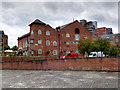
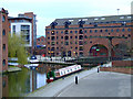
The Wharf, Castlefield Basin
Large pub and bar built during the regeneration of the Castlefield Basin area during the 1980s.
Image: © David Dixon
Taken: 4 Sep 2017
0.00 miles
2
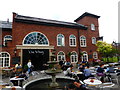
The Wharf public house
Built in 1998 in the local vernacular style to fit in with the surrounding canal side buildings, this opened as "Jackson's Wharf" but was unsuccessful. From closure in 2005 until 2011 it was under threat of demolition and replacement with a modern horror of some sort, but the plans were defeated by local activists, and the present building re-opened as a more successful pub soon afterwards.
Food, service, and ambience are exemplary, and I think the outcome was a good one.
See http://www.brunningandprice.co.uk/thewharf/history/ for the pub's own history page, from which most of these details come.
Image: © Bob Harvey
Taken: 22 May 2017
0.01 miles
3
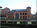
Castlefield Wharves
The wharves on the Bridgewater Canal at Castlefield as viewed from a temporarily stationary tram on the overlooking viaduct.
Image: © Gerald England
Taken: 1 Sep 2009
0.01 miles
4
Jackson's Wharf, Castlefield
Blantrye Street, Castlefield, MANCHESTER on the Bridgewater Canal
Image: © canalandriversidepubs co uk
Taken: 7 Apr 2010
0.01 miles
5
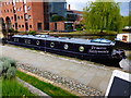
Modern narrowboat
Vessel "Princess Jazzymaid II" has stainless portholes, modern double glazing, inset solar panels, and weird atrium style skylights.
It's a narrowboat, but not as we know it Jim.
Seen here from the terrace of The Wharf public house
Image: © Bob Harvey
Taken: 22 May 2017
0.02 miles
6
Olde England
A narrowboat moored on the Bridgewater Canal at Castlefield.
Image: © Gerald England
Taken: 8 Jan 2017
0.02 miles
7
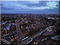
Night Scene, South Manchester
View from the Cloud 23 bar in the Beetham Tower (Hilton Hotel).
Image: © David Dixon
Taken: 3 Jul 2014
0.02 miles
8
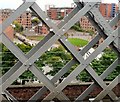
Castlefield canal basin
With some early spring greenery on view.
Image: © Thomas Nugent
Taken: 28 Feb 2011
0.02 miles
9

Castlefield Canal Basin, Manchester
Castlefield Basin was the terminus of the Bridgewater Canal and the wharves were at one time used for unloading coal and timber. It is now a fashionable venue, with pubs and canalside apartments alongside the canal heritage.
Image: © Martin Clark
Taken: 1 Dec 2002
0.02 miles
10
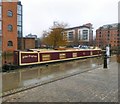
Castlefield Wharf
Canal boats moored on the Bridgewater Canal at Castlefield.
Image: © Gerald England
Taken: 1 Sep 2009
0.02 miles