IMAGES TAKEN NEAR TO
City Road East, MANCHESTER, M15 4RT
Introduction
This page details the photographs taken nearby to City Road East, M15 4RT by members of the Geograph project.
The Geograph project started in 2005 with the aim of publishing, organising and preserving representative images for every square kilometre of Great Britain, Ireland and the Isle of Man.

There are currently over 7.5m images from over14,400 individuals and you can help contribute to the project by visiting https://www.geograph.org.uk
Image Map
Images are licensed for reuse under creativecommons.org/licenses/by-sa/2.0
Notes
- Clicking on the map will re-center to the selected point.
- The higher the marker number, the further away the image location is from the centre of the postcode.
Image Listing (1206 Images Found)
Images are licensed for reuse under creativecommons.org/licenses/by-sa/2.0
Image
Details
Distance
1
Little Peter Street, Manchester
This is the area around the old Knott Mill station, now known as Deansgate Castlefield. A short distance beyond the station, I stopped on the corner of Little Peter Street, going away from the camera, and Commercial Street, going to the right.
Image: © Tricia Neal
Taken: 1 Apr 2014
0.02 miles
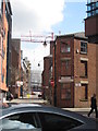
2
Gilbert Street
View looking down Gilbert Street with one of the towers of the Deansgate Square development in view.
Image: © Peter McDermott
Taken: 4 Nov 2018
0.02 miles
3
Granada TV studios, Coronation Street set
Photo taken in 1999, from the vicinity of Roy's Rolls. The woman in brown is actually the actress who played Vera Duckworth.
Image: © Darrin Antrobus
Taken: Unknown
0.02 miles
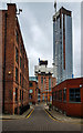
4
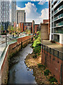
Constance Street, Manchester
This little corner of Manchester between Whitworth Street West and the River Medlock has narrow streets and small Victorian warehouses, now mostly converted to offices and flats. There is also a bit of post-war infill. The nearest building retains a vestige of its loading bay.
Beyond is the Beetham Tower (Image]).
Image: © Stephen Richards
Taken: 17 May 2012
0.02 miles
5
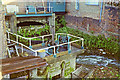
Bridgewater Canal run-off sluice
The excess canal water passes under Deansgate and discharges into the River Medlock.
Image: © Robin Webster
Taken: 24 Sep 1990
0.02 miles
7
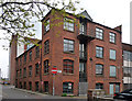
10a Little Peter Street, Manchester
Modest Victorian warehouse, now converted into flats/offices. A loading bay survives on the Constance Street front.
Image: © Stephen Richards
Taken: 17 May 2012
0.02 miles
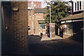
8
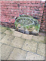
Boundary Stone, Knott Mill Bridge
Against the parapet of the bridge over the river Medlock. The stone marked the boundary between Manchester (St James Ward) and Hulme.
Grade II listed see https://historicengland.org.uk/listing/the-list/list-entry/1282975
Milestone Society National ID: LA_MANHUL01pb
Image: © Stef Tenzing
Taken: Unknown
0.03 miles
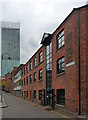
10
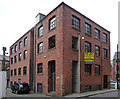
4 Jordan Street, Manchester
A modest Victorian warehouse/factory recently refurbished and converted to offices.
Image: © Stephen Richards
Taken: 17 May 2012
0.04 miles