IMAGES TAKEN NEAR TO
Waterways Avenue, MANCHESTER, M15 4QZ
Introduction
This page details the photographs taken nearby to Waterways Avenue, M15 4QZ by members of the Geograph project.
The Geograph project started in 2005 with the aim of publishing, organising and preserving representative images for every square kilometre of Great Britain, Ireland and the Isle of Man.

There are currently over 7.5m images from over14,400 individuals and you can help contribute to the project by visiting https://www.geograph.org.uk
Image Map
Images are licensed for reuse under creativecommons.org/licenses/by-sa/2.0
Notes
- Clicking on the map will re-center to the selected point.
- The higher the marker number, the further away the image location is from the centre of the postcode.
Image Listing (237 Images Found)
Images are licensed for reuse under creativecommons.org/licenses/by-sa/2.0
Image
Details
Distance
1
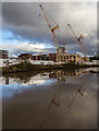
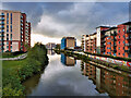
Bridgewater Canal
Development alongside the Bridgewater Canal.
Image: © Peter McDermott
Taken: 27 Nov 2016
0.01 miles
2
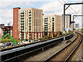
New Buildings near Cornbrook Station
New building development alongside the Ship canal, viewed from the platform of Cornbrook Metrolink Station.
Image: © David Dixon
Taken: 8 Aug 2019
0.02 miles
3
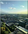
South Western rooftops of Manchester City Centre
Image: © Anthony Parkes
Taken: 24 Aug 2023
0.02 miles
4
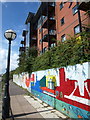
Mural, Steele House
Smart flats overlooking the Irwell, with a bright mural along the towpath.
Image: © Derek Harper
Taken: 19 Aug 2010
0.03 miles
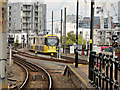
6
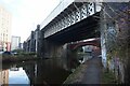
Metrolink viaduct
A tram heading for Altrincham crosses the old Cheshire Lines Committee viaduct shortly before crossing the Bridgewater Canal at Cornbrook. There is a marked contrast in brickwork colour and style between the CLC line and the Manchester South Junction and Altrincham of 1849. The CLC viaduct dates from 1880, when the lines were re-routed to the new Manchester Central Station Image, rising onto imposing steel girder bridges Image to gain sufficient height.
Image: © Jonathan Wilkins
Taken: 27 Jun 2010
0.04 miles
7
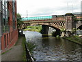
St Georges, railway bridges
Bridges over the Bridgewater Canal: the nearer, rail, the further, Metro.
Image: © Mike Faherty
Taken: 31 Aug 2009
0.04 miles
8
Manchester Ship Canal (River Irwell) at Pomona Wharf
A view looking downstream (towards the former docks at Salford Quays) from the Woden Street footbridge.
Image: © David Dixon
Taken: 2 Nov 2021
0.04 miles
9
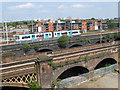
Tram Approaching Cornbrook
Metrolink tram number 3077 approaches Cornbrook Station on the route to East Didsbury.
Image: © David Dixon
Taken: 8 Aug 2019
0.04 miles
10
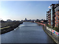
Manchester Ship Canal (River Irwell)
Downstream of the Woden Street footbridge (from where this photograph is taken), the River Irwell becomes the Manchester Ship Canal. This view is looking towards the Pomona Docks.
Image: © David Dixon
Taken: 1 Feb 2012
0.04 miles