IMAGES TAKEN NEAR TO
Worsley Street, MANCHESTER, M15 4NU
Introduction
This page details the photographs taken nearby to Worsley Street, M15 4NU by members of the Geograph project.
The Geograph project started in 2005 with the aim of publishing, organising and preserving representative images for every square kilometre of Great Britain, Ireland and the Isle of Man.

There are currently over 7.5m images from over14,400 individuals and you can help contribute to the project by visiting https://www.geograph.org.uk
Image Map
Images are licensed for reuse under creativecommons.org/licenses/by-sa/2.0
Notes
- Clicking on the map will re-center to the selected point.
- The higher the marker number, the further away the image location is from the centre of the postcode.
Image Listing (450 Images Found)
Images are licensed for reuse under creativecommons.org/licenses/by-sa/2.0
Image
Details
Distance
1
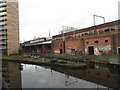
![Private canal basin, west of Egerton Road bridge [no 100]](https://s3.geograph.org.uk/geophotos/06/87/64/6876479_e8bbc9e7_120x120.jpg)
Private canal basin, west of Egerton Road bridge [no 100]
A boater's view. In 1915 there was a paper store on the east side of the basin and Worsley braid mills on the west side.
Image: © Christine Johnstone
Taken: 22 May 2021
0.01 miles
2
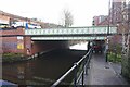
Bridgewater Canal, Hulme Locks
The top lock of the disused Hulme Locks at Hulme Junction, where the disused Hulme Locks Arm branches off the Bridgewater Canal. It descends three locks and turns sharply under the viaduct to link with the River Irwell. The locks are in poor condition now and the arm is no longer navigable. A new access to the River Irwell and Salford Quays has been made a little further west via Pomona Dock.
Image: © David Dixon
Taken: 4 Sep 2017
0.02 miles
3
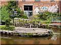
Cornbrook, disused lock
Lock on the Bridgewater Canal that once gave access to the Ship Canal; now protected by a stationary boat and boom. Above the lock, a long line of Metro trains, currently out of use because of system maintenance.
Image: © Mike Faherty
Taken: 31 Aug 2009
0.03 miles
5
Bridgewater Canal and apartment block
Image: © Philip Jeffrey
Taken: 11 May 2018
0.03 miles
6
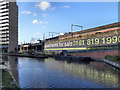
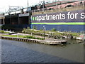
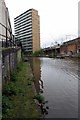
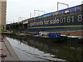
Bridgewater Canal, St George's Island
A giant poster on the side of the nineteenth century railway viaduct advertises the twenty first century apartments which have replaced the decaying industrial buildings as the area has undergone regeneration.
The apartment block is on a small promontory of land known as “St George’s Island” close to the Mancunian Way. The water between the apartments and the viaduct was the Hulme Locks Junction Canal which once formed an important connection between the Bridgewater Canal and the River Irwell / Manchester Ship Canal. The Hulme Locks Junction Canal was only 200 metres in length. It opened in 1938 but has fallen into a state decline today having been replaced by a new lock which was built in 1995 near to Pomona Dock Number 3.
http://manchesterhistory.net/manchester/outside.html - Manchester History Net
Image: © David Dixon
Taken: 1 Feb 2012
0.03 miles
7

Hulme Locks, 1990
The entrance lock from the Bridgewater Canal to the short connection with the Manchester Ship Canal. This lock was not used as a lock, as the original three locks had been replaced by a single deep lock around the corner under the railway in the 1960s. In 1990 however, this route was open. It was closed in 1995, as replaced by a new lock connecting to Pomona Dock further downstream.
Image: © Robin Webster
Taken: 18 Sep 1990
0.03 miles
8
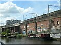
Former Hulme Locks branch of the Bridgewater Canal
At the junction with the Bridgewater Canal. Built in 1838 to connect the Rochdale Canal and the Mersey & Irwell Navigation [forerunner of the Manchester Ship Canal]. Fell out of use in 1995 when the more convenient Pomona lock was opened.
Image: © Christine Johnstone
Taken: 22 May 2021
0.03 miles
9
Hulme Junction
This was the old link between the Bridgewater Canal and Manchester Docks. It has been replaced by the new Pomona Lock a bit further south west.
Image: © Alan Murray-Rust
Taken: 18 Sep 2009
0.03 miles