IMAGES TAKEN NEAR TO
Hulme Hall Road, MANCHESTER, M15 4LY
Introduction
This page details the photographs taken nearby to Hulme Hall Road, M15 4LY by members of the Geograph project.
The Geograph project started in 2005 with the aim of publishing, organising and preserving representative images for every square kilometre of Great Britain, Ireland and the Isle of Man.

There are currently over 7.5m images from over14,400 individuals and you can help contribute to the project by visiting https://www.geograph.org.uk
Image Map
Images are licensed for reuse under creativecommons.org/licenses/by-sa/2.0
Notes
- Clicking on the map will re-center to the selected point.
- The higher the marker number, the further away the image location is from the centre of the postcode.
Image Listing (235 Images Found)
Images are licensed for reuse under creativecommons.org/licenses/by-sa/2.0
Image
Details
Distance
1
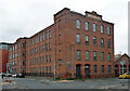
Albert Mill, Ellesmere Street, Manchester
Former cotton mill dated 1869 on the return. The listing remarks that "timber-floored construction (at this date) suggests use for one of the specialised minor branches of the textile industry." Grade II listed.
Now offices and flats above.
Image: © Stephen Richards
Taken: 29 May 2017
0.00 miles
2
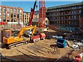
Excelsior Mill
The new 'Excelsior Mill' residential development.
Image: © Peter McDermott
Taken: 2 Sep 2018
0.02 miles
3
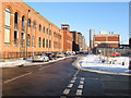
Ellesmere Street
Brick-built warehouses have been converted for residential and commercial use.
Image: © Jonathan Wilkins
Taken: 19 Dec 2010
0.03 miles
4
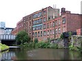
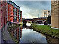
Bridgewater canal and derelict buildings
This landscape is being steadily erased and replaced with modern apartments.
Image: © David Martin
Taken: 1 Aug 2010
0.03 miles
5
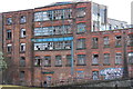
Excelsior Mill
Now demolished Excelsior Mill, seen in 2013.
Image: © Phill
Taken: 13 Mar 2013
0.03 miles
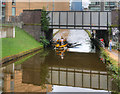
7
![Private canal basin, west of Hulme Hall Road bridge [no 99]](https://s0.geograph.org.uk/geophotos/06/87/64/6876492_98b1d5e6_120x120.jpg)
Private canal basin, west of Hulme Hall Road bridge [no 99]
A boater's view. In 1915 this served a timber yard and saw mill.
Image: © Christine Johnstone
Taken: 22 May 2021
0.04 miles
8
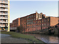
Bridgewater Canal, St George's
This derelict building is in stark contrast to the modern apartments which have sprung up on either side of the Bridgewater Canal as part of the redevelopment of the Castlefield area.
Image: © David Dixon
Taken: 1 Feb 2012
0.04 miles
9
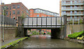
Waxi on the Bridgewater Canal
"Waxi" (water taxi https://www.manchesterwatertaxis.com/ ) under the bridge at Hulme Hall Road. The Manchester Water Taxis provide a passenger service between the Castlefield Basin and Salford Quays, Old Trafford and the Trafford Centre, along the Bridgewater Canal.
Image: © David Dixon
Taken: 4 Sep 2017
0.04 miles