IMAGES TAKEN NEAR TO
Burton Place, MANCHESTER, M15 4LR
Introduction
This page details the photographs taken nearby to Burton Place, M15 4LR by members of the Geograph project.
The Geograph project started in 2005 with the aim of publishing, organising and preserving representative images for every square kilometre of Great Britain, Ireland and the Isle of Man.

There are currently over 7.5m images from over14,400 individuals and you can help contribute to the project by visiting https://www.geograph.org.uk
Image Map
Images are licensed for reuse under creativecommons.org/licenses/by-sa/2.0
Notes
- Clicking on the map will re-center to the selected point.
- The higher the marker number, the further away the image location is from the centre of the postcode.
Image Listing (261 Images Found)
Images are licensed for reuse under creativecommons.org/licenses/by-sa/2.0
Image
Details
Distance
1
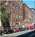
Talbot Mill, Ellesmere Street, Manchester
Former textile mill consisting of two plain four-storey ranges.
Mostly, if not entirely, empty at the time, it is, like everything else, scheduled for conversion to flats (2023).
Image: © Stephen Richards
Taken: 17 Aug 2016
0.03 miles
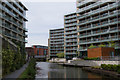
2
St. Georges Island
New flats on the canal bank still being built July 2007
Image: © Keith Burroughs
Taken: 1 Jul 2007
0.04 miles
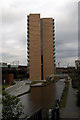
3
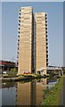
Leaning Towers
Two high rise towers, part of a canalside development, Castlefield, Manchester UK
Image: © D M Wilmot
Taken: 5 Jul 2013
0.04 miles
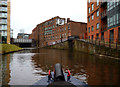
4
![Private canal basin, east of Hulme Hall Road bridge [no 99]](https://s1.geograph.org.uk/geophotos/06/87/63/6876381_0cd51c5c_120x120.jpg)
Private canal basin, east of Hulme Hall Road bridge [no 99]
A boater's view. In 1915 there were three mills around this basin - a cotton mill, Talbot Mills [cotton and braid] and Britannia Emery Mills
Image: © Christine Johnstone
Taken: 22 May 2021
0.05 miles
5
Basin on Bridgewater Canal near Hulme Hall Road Bridge
Image: © Ian S
Taken: 1 Mar 2022
0.05 miles
6
Apartments overlooking the Bridgewater Canal
A transformed landscape!
Image: © Bill Boaden
Taken: 4 Sep 2010
0.05 miles
7
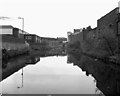
Bridgewater Canal, central Manchester
As seen in 1981. In the distance, a railway is seen on the left - this is now part of the Manchester tram system.
Image: © Dr Neil Clifton
Taken: 12 Apr 1981
0.05 miles
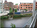
9
Bridgewater Canal: Junction with old side arm
The roving bridge on the right crosses an old side-arm, very short and no longer navigable.
Image: © Dr Neil Clifton
Taken: 29 Mar 2015
0.06 miles
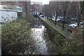
10
Cornbrook, canal basin
Disused basin off the Bridgewater Canal, leading to an industrial estate.
Image: © Mike Faherty
Taken: 31 Aug 2009
0.06 miles