IMAGES TAKEN NEAR TO
Eastham Avenue, MANCHESTER, M14 7AT
Introduction
This page details the photographs taken nearby to Eastham Avenue, M14 7AT by members of the Geograph project.
The Geograph project started in 2005 with the aim of publishing, organising and preserving representative images for every square kilometre of Great Britain, Ireland and the Isle of Man.

There are currently over 7.5m images from over14,400 individuals and you can help contribute to the project by visiting https://www.geograph.org.uk
Image Map
Images are licensed for reuse under creativecommons.org/licenses/by-sa/2.0
Notes
- Clicking on the map will re-center to the selected point.
- The higher the marker number, the further away the image location is from the centre of the postcode.
Image Listing (20 Images Found)
Images are licensed for reuse under creativecommons.org/licenses/by-sa/2.0
Image
Details
Distance
1
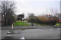
An entrance to Platt Fields Park
A busy park in South Manchester. This entrance is at the quieter end off Hart Road.
Image: © Bill Boaden
Taken: 27 Dec 2012
0.08 miles
2
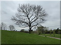
Beech tree in Platt Fields Park
Platt Fields Park, was formally opened on 7 May 1910 by the Lord Mayor of Manchester, Sir Charles Behrens, the land having been purchased for public parkland in 1908 from Elizabeth Tindal-Carill-Worsley at a cost of £59,975.
Image: © Rod Allday
Taken: 12 Apr 2014
0.13 miles
4
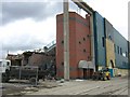
Maine Road Football Ground
Former home of Manchester City FC being demolished
Image: © Tony Smith
Taken: 5 Apr 2004
0.14 miles
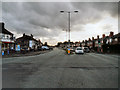
6
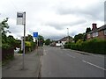
Fallowfield - Yew Tree Road meets Wilbraham Road
Image: © Peter Whatley
Taken: 31 Mar 2009
0.16 miles
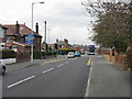
7
Wilbraham Road
An important east/west route traversing South Manchester, the A6010, seen here at its junction with Yew Tree Road.
Image: © Bill Boaden
Taken: 27 Dec 2012
0.17 miles
8
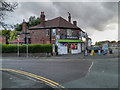
Corner Shop
A "corner shop" on the corner of Yew Tree Road and Wilbraham Road in Fallowfield.
Image: © David Dixon
Taken: 17 Sep 2012
0.18 miles
9
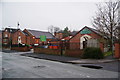
St Kentigern's Church and Social Club
Active RC complex on Hart Road.
Image: © Bill Boaden
Taken: 27 Dec 2012
0.18 miles
10
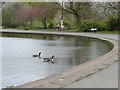
The western end of the boating lake in Platt Fields Park
Image: © Rod Allday
Taken: 12 Apr 2014
0.18 miles