IMAGES TAKEN NEAR TO
Wilbraham Road, MANCHESTER, M14 6DL
Introduction
This page details the photographs taken nearby to Wilbraham Road, M14 6DL by members of the Geograph project.
The Geograph project started in 2005 with the aim of publishing, organising and preserving representative images for every square kilometre of Great Britain, Ireland and the Isle of Man.

There are currently over 7.5m images from over14,400 individuals and you can help contribute to the project by visiting https://www.geograph.org.uk
Image Map
Images are licensed for reuse under creativecommons.org/licenses/by-sa/2.0
Notes
- Clicking on the map will re-center to the selected point.
- The higher the marker number, the further away the image location is from the centre of the postcode.
Image Listing (51 Images Found)
Images are licensed for reuse under creativecommons.org/licenses/by-sa/2.0
Image
Details
Distance
1
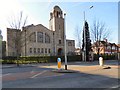
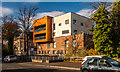
Former South Manchester Synagogue, Fallowfield
The Grade II listed https://historicengland.org.uk/listing/the-list/list-entry/1254890 synagogue by Joseph Sunlight opened in 1913. In 2003 the congregation moved to a new building in Bowden. The building has been converted into a residential Jewish student centre.
Image: © Gerald England
Taken: 15 Feb 2019
0.07 miles
2
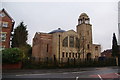
Former South Manchester Synagogue
This is a Grade II listed building completed in 1913. The South Manchester Synagogue has relocated to Bowdon, but plans are in hand to develop this as an educational centre.
Image: © Bill Boaden
Taken: 27 Dec 2012
0.08 miles
3
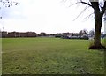
Platt Fields Park
Looking towards the Skate Park and the BMX Track.
The Platt Fields estate was purchased by Manchester Corporation for public use in 1907 following a local campaign. The park was landscaped and a lake created by unemployed labour during the hard winter of 1908-1909. Platt Fields Park, was formally opened on 7 May 1910 by the Lord Mayor of Manchester, Sir Charles Behrens. The Main Lake was provided with a large boat house and wood covered slipway. It housed not only a fleet of large, clinker built rowing boats and skiffs but also a fine motor launch, the Archie Littlemore, which gave rides during the summer months.
A full list of the park's facilities and further information can be found on the website of the Friends of Platt Fields: http://www.plattfields.org/stuff.htm
Image: © Gerald England
Taken: 9 Feb 2019
0.09 miles
5
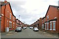
Fallowfield
New houses on Wilbraham Road in Fallowfield.
Image: © Peter McDermott
Taken: 1 Nov 2014
0.10 miles
6
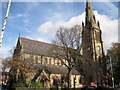
Holy Innocents, Fallowfield
One of the few Anglican churches dedicated to the Holy Innocents: these were the children slain by King Herod. The church was built between 1870-72, architects Price & Linklater, on land given by Lord Egerton. The style is Gothic revival and its construction is of sandstone masonry. The tower is topped by an octagonal spire, added around 1880 and the stained glass windows are mostly of the 1890's.
Image: © Sue Adair
Taken: 28 Oct 2009
0.12 miles
7
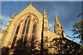
Church of the Holy Innocents: from the West
The west window and the spire
Image: © Bob Harvey
Taken: 14 Oct 2015
0.12 miles
8
Church of the Holy Innocents: West Window
Image: © Bob Harvey
Taken: 14 Oct 2015
0.12 miles
9
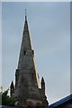
Holy Innocents, Fallowfield: The Spire
A superbly built thing, this spire. Look at the way the late afternoon sun is catching it.
Image: © Bob Harvey
Taken: 14 Oct 2015
0.13 miles
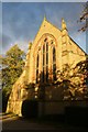
10
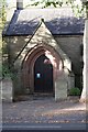
Church of the Holy Innocents: the Porch
Image: © Bob Harvey
Taken: 14 Oct 2015
0.13 miles