IMAGES TAKEN NEAR TO
Platt Lane, MANCHESTER, M14 5NE
Introduction
This page details the photographs taken nearby to Platt Lane, M14 5NE by members of the Geograph project.
The Geograph project started in 2005 with the aim of publishing, organising and preserving representative images for every square kilometre of Great Britain, Ireland and the Isle of Man.

There are currently over 7.5m images from over14,400 individuals and you can help contribute to the project by visiting https://www.geograph.org.uk
Image Map
Images are licensed for reuse under creativecommons.org/licenses/by-sa/2.0
Notes
- Clicking on the map will re-center to the selected point.
- The higher the marker number, the further away the image location is from the centre of the postcode.
Image Listing (60 Images Found)
Images are licensed for reuse under creativecommons.org/licenses/by-sa/2.0
Image
Details
Distance
1
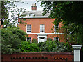
66 Platt Lane, Manchester
One of two houses (with no. 68) built c1830, each with an Ionic porch. Grade II listed.
Image: © Stephen Richards
Taken: 12 Jun 2016
0.01 miles
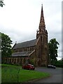
3
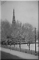
Holy Trinity Church
Holy Trinity Church at the edge of Platt Fields Park.
Image: © Peter McDermott
Taken: 15 Feb 2015
0.06 miles
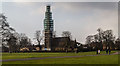
5
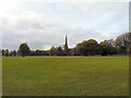
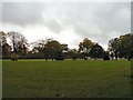
Platt Fields Park
The Platt Fields estate was purchased by Manchester Corporation for public use in 1907 following a local campaign. The park was landscaped and a lake created by unemployed labour during the hard winter of 1908-1909.
In the background is Holy Trinity Church which was built in 1845-46, at the expense of Thomas Carrill Worsley of Platt Hall. http://rusholmearchive.org/holy-trinity-church-platt-lane
Image: © Gerald England
Taken: 18 Oct 2010
0.07 miles
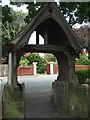
7
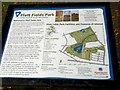
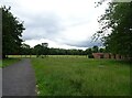
Welcome to Platt Fields Park
Information board to one of the entrances to the park.
Image: © Gerald England
Taken: 18 Oct 2010
0.07 miles
8
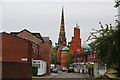
Victory Street, Rusholme
It has a relatively new mosque, with behind it the spire of Holy Trinity, Platt.
Image: © Bill Boaden
Taken: 29 Jul 2011
0.08 miles
9
Church in Platt Fields Park.
Taken in the Winter of 1957, before leaving the following June for Australia.
Image: © Frank Airey
Taken: 1 Dec 1957
0.10 miles
10
Platt Fields Park
The Platt Fields estate was purchased by Manchester Corporation for public use in 1907 following a local campaign. The park was landscaped and a lake created by unemployed labour during the hard winter of 1908-1909.
Image: © Gerald England
Taken: 18 Oct 2010
0.10 miles