IMAGES TAKEN NEAR TO
Booth Street East, MANCHESTER, M13 9EP
Introduction
This page details the photographs taken nearby to Booth Street East, M13 9EP by members of the Geograph project.
The Geograph project started in 2005 with the aim of publishing, organising and preserving representative images for every square kilometre of Great Britain, Ireland and the Isle of Man.

There are currently over 7.5m images from over14,400 individuals and you can help contribute to the project by visiting https://www.geograph.org.uk
Image Map
Images are licensed for reuse under creativecommons.org/licenses/by-sa/2.0
Notes
- Clicking on the map will re-center to the selected point.
- The higher the marker number, the further away the image location is from the centre of the postcode.
Image Listing (285 Images Found)
Images are licensed for reuse under creativecommons.org/licenses/by-sa/2.0
Image
Details
Distance
1
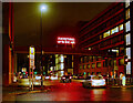
Everything Up in the Air - the Bridge over Booth Street East
Everything Up in the Air is a new, Neon artwork by artist and writer Tim Etchells. It was commissioned for Corridor of Light.
Image: © David Dixon
Taken: 22 Oct 2021
0.02 miles
2
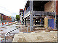
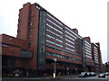
Demolition of University Precinct on Oxford Road
The iconic, 46-year-old precinct centre bridge over Oxford Road (see Image] ) has been taken down and the end of the precinct is being demolished prior to being reconfigured to create up to 14 units with glazed frontages onto Oxford Road. The link bridge was removed to improve views and increase light levels. The work is taking place as part of Manchester University’s £50m redevelopment of Manchester Business School.
https://www.placenorthwest.co.uk/news/oxford-road-bridge-demolition-begins-next-week/#sthash.tdtcUzN6.dpuf
Image: © David Dixon
Taken: 20 Aug 2016
0.02 miles

4
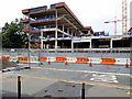
Redevelopment of University Precinct on Oxford Road
The iconic, 46-year-old precinct centre bridge over Oxford Road (see Image] ) has been taken down and the end of the precinct is being demolished prior to being reconfigured to create up to 14 units with glazed frontages onto Oxford Road. The link bridge was removed to improve views and increase light levels. The work is taking place as part of Manchester University’s £50m redevelopment of Manchester Business School.
https://www.placenorthwest.co.uk/news/oxford-road-bridge-demolition-begins-next-week/#sthash.tdtcUzN6.dpuf
Image: © David Dixon
Taken: 20 Aug 2016
0.03 miles
5

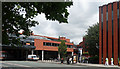
Oxford Road
Buildings on Oxford Road.
Image: © Peter McDermott
Taken: 20 May 2017
0.03 miles
6
St Peter's House, Oxford Road, Manchester
Conceived as part of Wilson & Womersley's extensive 1970-72 Precinct Centre development, which runs west (Image]), but executed by Cruickshank & Seward. The walkway across Oxford Road (left) is the only one remaining. It comes to an abrupt and cursory end since the demolition of the Maths Tower.
St Peter's House "provides chaplaincy to all the universities in Manchester".
On the far right is a bit of the Kilburn Building (Image]).
Image: © Stephen Richards
Taken: 25 Jul 2011
0.03 miles
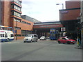
8

Royal Northern College of Music
The corner of Oxford Road and Booth Street West.
Image: © David Dixon
Taken: 13 Jul 2010
0.04 miles
9

Royal Northern College of Music, Oxford Road, Manchester
The Booth Street front (left) is concrete and by Bickerdike, Allen, Rich & Partners, 1968-73. The Oxford Road front is softer, and probably dates from the late 1990s or early 2000s.
A walkway used to run across Booth Street to the Precinct Centre (Image]).
The college offers undergraduate and postgraduate courses, and has been around in one form or another since 1893.
Image: © Stephen Richards
Taken: 17 May 2012
0.04 miles
10
University of Manchester buildings across Oxford Road
This University of Manchester building was a conspicuous feature on the map and in reality, as it spanned the busy Oxford Road. Demolished in 2015 - see https://www.youtube.com/watch?v=Rkp8k-qnptk
Image: © David Martin
Taken: 2 Apr 2008
0.04 miles