IMAGES TAKEN NEAR TO
Alwyn Drive, MANCHESTER, M13 0YD
Introduction
This page details the photographs taken nearby to Alwyn Drive, M13 0YD by members of the Geograph project.
The Geograph project started in 2005 with the aim of publishing, organising and preserving representative images for every square kilometre of Great Britain, Ireland and the Isle of Man.

There are currently over 7.5m images from over14,400 individuals and you can help contribute to the project by visiting https://www.geograph.org.uk
Image Map
Images are licensed for reuse under creativecommons.org/licenses/by-sa/2.0
Notes
- Clicking on the map will re-center to the selected point.
- The higher the marker number, the further away the image location is from the centre of the postcode.
Image Listing (49 Images Found)
Images are licensed for reuse under creativecommons.org/licenses/by-sa/2.0
Image
Details
Distance
1

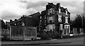
Inner city terraced houses - Rusholme
-
Image: © Jeff Thomas
Taken: 21 Apr 2005
0.10 miles
2
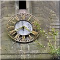
St John's Clock
Clock on the former St John's Church Image
Image: © Gerald England
Taken: 29 Apr 2017
0.11 miles
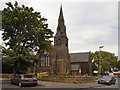
3
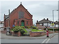
St John's, Longsight
The former Church of St. John the Apostle and Evangelist was founded in 1846. The oldest of the churches in Longsight, in 1979 St John's amalgamated with St Cypian's Church. It closed in 1993. It is now The Qadria Jilania Islamic Centre. http://manchesterhistory.net/LONGSIGHT/CHURCH/stjohns.html
Image: © Gerald England
Taken: 29 Apr 2017
0.11 miles
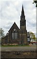
4
Church of St John the Apostle and Evangelist
The Church of St John the Apostle and Evangelist is on the corner of Holmfirth Street and St John's Road, in Longsight,
Built between 1845 and 1846, It is the oldest of the churches in Longsight. When it opened, the church was capable of holding 900 worshippers. It closed in 1993 and has since re-opened as an Islamic Centre.
The building is Grade II listed (http://manchesterhistory.net/LONGSIGHT/CHURCH/stjohns.html Manchester History Net).
Image: © David Dixon
Taken: 19 Aug 2011
0.12 miles
5
St John's, Longsight
The former Church of St. John the Apostle and Evangelist was founded in 1846. The oldest of the churches in Longsight, in 1979 St John's amalgamated with St Cypian's Church. It closed in 1993. It is now The Qadria Jilania Islamic Centre. http://manchesterhistory.net/LONGSIGHT/CHURCH/stjohns.html
Image: © Gerald England
Taken: 29 Apr 2017
0.12 miles
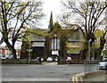
6
Levenshulme
Property on the corner of Dickenson Road and Birch Lane in Levenshulme,
Image: © Peter McDermott
Taken: 17 Sep 2018
0.14 miles
7
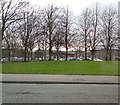
St John's Green
Green space at Longsight between Stockport Road and St John's Road.
Image: © Gerald England
Taken: 21 Mar 2012
0.14 miles
8
Victoria Park Christian Fellowship
An independent, evangelical church in Daisy Bank Road.
Image: © Rod Allday
Taken: 12 Apr 2014
0.16 miles
9
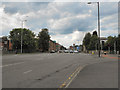
A6 (Stockport Road) Longsight
Stockport Road, at its junction with Kirkmanshulme Lane (A6010).
Image: © David Dixon
Taken: 19 Aug 2011
0.16 miles
10
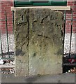
Old Boundary Marker by the A6, Stockport Road, Longsight, Manchester
Parish Boundary Marker on the west side of the A6 Stockport Road, Longsight, against the railings of the Plymouth Point development, opposite Newton Avenue. On the boundary of Moss Side and Rusholme townships. Both were parishes after 1866. Formerly recorded as milestone LA_BAPIC01 but shown as a boundary stone on old Ordnance Survey maps. See also https://images.manchester.gov.uk/collections/415e4c2e-8635-3d94-ad48-410959bc8510/?s%3D%26filter%5Bsubject.summary.title.keyword%5D%5B%5D%3DBoddan%2BPlace&pos=3 and http://www.flickr.com/photos/48274996@N08/5258726224/.
Milestone Society National ID: LA_MANC03pb
Image: © M Faherty
Taken: 15 Jul 2007
0.16 miles