IMAGES TAKEN NEAR TO
Chapeltown Street, MANCHESTER, M1 2NN
Introduction
This page details the photographs taken nearby to Chapeltown Street, M1 2NN by members of the Geograph project.
The Geograph project started in 2005 with the aim of publishing, organising and preserving representative images for every square kilometre of Great Britain, Ireland and the Isle of Man.

There are currently over 7.5m images from over14,400 individuals and you can help contribute to the project by visiting https://www.geograph.org.uk
Image Map
Images are licensed for reuse under creativecommons.org/licenses/by-sa/2.0
Notes
- Clicking on the map will re-center to the selected point.
- The higher the marker number, the further away the image location is from the centre of the postcode.
Image Listing (1558 Images Found)
Images are licensed for reuse under creativecommons.org/licenses/by-sa/2.0
Image
Details
Distance
1
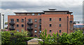
Home Apartments
Apartment block behind Piccadilly Station.
Image: © Peter McDermott
Taken: 17 May 2015
0.01 miles
2
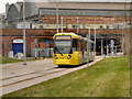
Metrolink, Baird Street
Metrolink Bombardier tram number 3019 on Baird Street having just emerged from the Piccadilly Station Undercroft which can be seen behind it in the picture. The tram was engaged in driver familiarisation/route testing for the East Manchester extension due to be opened the following week (11th Feb).
Image: © David Dixon
Taken: 7 Feb 2013
0.04 miles
3
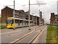
Trams on Baird Street
The new section of tramway outside Piccadilly Station. Part of the Metrolink East Manchester Extension which will operate initially to Droylsden, and eventually to Ashton-Under-Lyne.
Image: © David Dixon
Taken: 21 Nov 2012
0.05 miles
4

Tram on Test
Metrolink Bombardier tram 3058 on Baird Street. 3058 (and the others behind) are being used for "driver route familiarisation" to test the new East Manchester Extension which will run initially to Droylsden and eventually to Ashton-Under-Lyne.
Image: © David Dixon
Taken: 21 Nov 2012
0.05 miles
5
Tram development, Baird Street, Manchester
Fairly sure this will be the East Manchester line which will run to Droylsden (by 2012) and Ashton-under-Lyne (by 2013-14). It will continue the line from the current terminus at Piccadilly - stationary trams were visible almost immediately behind the photographer. It neatly threads its way between existing buildings or over patches of wasteland, although it has entailed the loss of Baird Street to vehicles (probably no great loss as it was a short road which no longer served much purpose).
Image: © Stephen Richards
Taken: 24 Jul 2011
0.05 miles
6

Metrolink Extension, Baird Street
Metrolink Bombardier trams testing the new East Manchester Extension to the network. The new line will run initially as far as Droylsden, and eventually to Ashton-Under-Lyne.
Image: © David Dixon
Taken: 21 Nov 2012
0.05 miles
7

East Manchester Extension to Metrolink
Metrolink Bombardier trams 3056 and 3058 stand on Baird Street, outside Piccadilly Station. The trams are currently being used for "driver route familiarisation" and "line testing" prior to the start of the service which will run from Piccadilly Station towards Droylsden (and eventually, Ashton-Under-Lyne).
Image: © David Dixon
Taken: 21 Nov 2012
0.05 miles
8
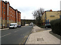
Manchester: Store Street
Store Street is a wide but not well-used street, linking through from the ring road (Great Ancoats Street) to London Road. It seems strange that it does not carry very much traffic. Here it is seen looking east towards the Ashton Canal Aqueduct. The small road on the right is Sparkle Street.
Image: © Dr Neil Clifton
Taken: 8 Feb 2010
0.05 miles
9
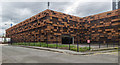
Sparkle Street
Car park on Sparkle Street in Manchester.
Image: © Peter McDermott
Taken: 17 May 2015
0.05 miles
10
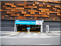
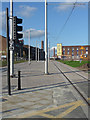
Permit Holders Only Entrance
Piccadilly station car park on Boad Street.
Image: © John Topping
Taken: 13 Mar 2013
0.06 miles