IMAGES TAKEN NEAR TO
Bond Street Industrial Estate, Mancunian Way, MANCHESTER, M12 6HW
Introduction
This page details the photographs taken nearby to Bond Street Industrial Estate, Mancunian Way, M12 6HW by members of the Geograph project.
The Geograph project started in 2005 with the aim of publishing, organising and preserving representative images for every square kilometre of Great Britain, Ireland and the Isle of Man.

There are currently over 7.5m images from over14,400 individuals and you can help contribute to the project by visiting https://www.geograph.org.uk
Image Map
Images are licensed for reuse under creativecommons.org/licenses/by-sa/2.0
Notes
- Clicking on the map will re-center to the selected point.
- The higher the marker number, the further away the image location is from the centre of the postcode.
Image Listing (509 Images Found)
Images are licensed for reuse under creativecommons.org/licenses/by-sa/2.0
Image
Details
Distance
1
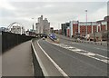
Mancunian Way
The beginning of the Mancunian Way, A57(M), as the A635 from Ashton enters Manchester. Non-motorway traffic must take the slipway onto the A6 Downing Street.
Image: © Gerald England
Taken: 21 Mar 2012
0.02 miles
2
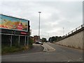
Sliproad to end of Mancunian Way
Slip road from the end of Baring Street onto the end of the Eastbound Mancunian Way.
Image: © Gerald England
Taken: 14 Aug 2009
0.03 miles
3
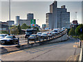
Mancunian Way
Traffic leaving the eastern end of the A57M, onto the A635.
The Mancunian Way is a two mile-long stretch of elevated urban motorway in Manchester which forms the southern part of the Manchester and Salford Inner Ring Road. It was constructed in two phases between 1963 and 1967 and was officially opened by then-Prime Minister, Harold Wilson, on 5 May 1967. At the time of its opening, the Manchester Evening News referred to it as the "highway in the sky". In the 1970s it was upgraded to motorway status as the A57(M) and the speed limit was raised to 50 miles per hour (80 km/h). It is officially made up of the A57(M) and A635(M) motorways, although the latter does not appear on road signs for practical reasons.
Image: © David Dixon
Taken: 21 Sep 2020
0.04 miles
4
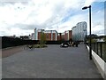
Walking in Mayfield Park
The highrise buildings in the background are mostly student accommodation.
Image: © Gerald England
Taken: 24 Sep 2022
0.04 miles
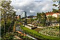
5
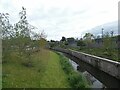
Mayfield Park
Through the middle flows the River Medlock.
Image: © Gerald England
Taken: 24 Sep 2022
0.05 miles
6
The River Medlock flowing through Mayfield Park
The highrise buildings in the background are mostly student accommodation.
Image: © Gerald England
Taken: 24 Sep 2022
0.05 miles
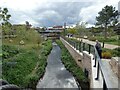
7
Bridges over the River Medlock
The construction of Mayfield Park involved the creation of a number of new bridges over the river. These allow easy access from one side of the park to the other. In the background is Depot Mayfield.
Image: © Gerald England
Taken: 24 Sep 2022
0.06 miles
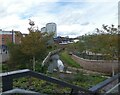
8
Mayfield Park
The new Mayfield Park development alongside the River Medlock.
Image: © Peter McDermott
Taken: 18 Sep 2022
0.07 miles
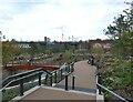
9
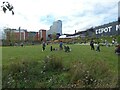
Mayfield Park
This section has a large area of grassland suitable for sunbathing, picnicking or playing games. On the right is the former Mayfield Station, now Depot Mayfield. The highrise buildings in the background are mostly student accommodation.
Image: © Gerald England
Taken: 24 Sep 2022
0.07 miles
10
Mayfield Park
The River Medlock flows through it.
Image: © Gerald England
Taken: 24 Sep 2022
0.07 miles