IMAGES TAKEN NEAR TO
Clowes Street, MANCHESTER, M12 5JE
Introduction
This page details the photographs taken nearby to Clowes Street, M12 5JE by members of the Geograph project.
The Geograph project started in 2005 with the aim of publishing, organising and preserving representative images for every square kilometre of Great Britain, Ireland and the Isle of Man.

There are currently over 7.5m images from over14,400 individuals and you can help contribute to the project by visiting https://www.geograph.org.uk
Image Map
Images are licensed for reuse under creativecommons.org/licenses/by-sa/2.0
Notes
- Clicking on the map will re-center to the selected point.
- The higher the marker number, the further away the image location is from the centre of the postcode.
Image Listing (117 Images Found)
Images are licensed for reuse under creativecommons.org/licenses/by-sa/2.0
Image
Details
Distance
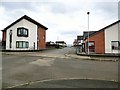
1

Clowes Street
New houses on Clowes Street.
Image: © Peter McDermott
Taken: 30 Nov 2014
0.02 miles
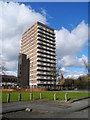
2
St Benedict's Avenue
Until a few years ago this area of West Gorton had a number of high-rise and three/four storey apartment blocks. Those have been demolished in recent years and replaced with a number of low-rise properties.
Image: © Gerald England
Taken: 16 Mar 2017
0.06 miles
3
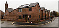
West Gorton
New houses in West Gorton.
Image: © Peter McDermott
Taken: 2 Apr 2018
0.09 miles
4
Wenlock Court, West Gorton
On the corner of Wenlock Way and Kniveton Road. Viewed from Skarratt Close.
Image: © John Topping
Taken: 13 Mar 2013
0.10 miles
5
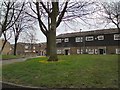
Brunet Walk
Between Wenlock Way and Clowes Street, West Gorton.
Image: © Gerald England
Taken: 21 Mar 2012
0.10 miles
7
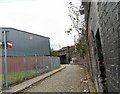
Toll Bar Street
Cobbled street by the railway off Hyde Road leading into Grey Street.
Image: © Gerald England
Taken: 29 Aug 2009
0.11 miles
8
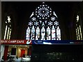
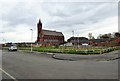
Base Camp Cafe
St Benedict's church, a fine and lofty Victorian structure, Grade II listed, closed as a place of religious worship in the early 21st century and has now been given a new lease of life as the Manchester Climbing Centre. Among its ecclesiastical treasures are two windows (not shown here) by the Arts & Crafts Stained Glass artist, Margaret Edith Rope.
In this view, an elevated platform below the east window is occupied by a cafe and a climbing equipment shop. The climbing walls occupy the centre of the nave.
A note on a Geograph discussion thread informs us that Myra Hindley attended this church.
Image: © Zorba the Geek
Taken: 14 Dec 2010
0.11 miles
9
Kniveton Road, West Gorton
At the junction with Wenlock Way.
Image: © John Topping
Taken: 13 Mar 2013
0.11 miles
10
St Benedict's Square
View from the corner of Trowtree Avenue and Reabrook Avenue towards St Benedict's Church Image now Manchester Climbing Centre http://www.climbingcentregroup.com/centres/manchester/
Before 2014 this view would have been blocked four-storey blocks of flats. In recent year this area of West Gorton has seen much of the old housing stock demolished and replaced by low-rise housing.
Image: © Gerald England
Taken: 16 Mar 2017
0.11 miles