IMAGES TAKEN NEAR TO
Eastern-by-Pass, MANCHESTER, M11 4NW
Introduction
This page details the photographs taken nearby to Eastern-by-Pass, M11 4NW by members of the Geograph project.
The Geograph project started in 2005 with the aim of publishing, organising and preserving representative images for every square kilometre of Great Britain, Ireland and the Isle of Man.

There are currently over 7.5m images from over14,400 individuals and you can help contribute to the project by visiting https://www.geograph.org.uk
Image Map
Images are licensed for reuse under creativecommons.org/licenses/by-sa/2.0
Notes
- Clicking on the map will re-center to the selected point.
- The higher the marker number, the further away the image location is from the centre of the postcode.
Image Listing (121 Images Found)
Images are licensed for reuse under creativecommons.org/licenses/by-sa/2.0
Image
Details
Distance
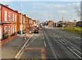
1
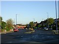
Eastern By-Pass!
This road in Clayton is a relic of a road scheme that ended before completion. This section of the Manchester Eastern By-Pass dates, I guess, from the 1930/40's judging by the style of the housing here. It is about 150 metres in length. The only other evidence I have found for this scheme is a similar section in nearby Openshaw Image
Image: © Keith Williamson
Taken: 28 Sep 2005
0.06 miles
2
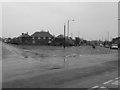
Eastern By-Pass, Clayton
Taken on Monday 4th April 2011 from the corner of Stanton Street and Canberra Street
Image: © Mikey
Taken: 4 Apr 2011
0.06 miles
5
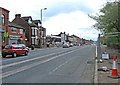
Ashton New Road
The A662 through Clayton. Metrolink tramlines run down the middle of the road. The houses on the left set slightly back from the rest of the terrace were Wallace's florists in 2008 (when the Google streetview car passed by).
Image: © Gerald England
Taken: 1 Mar 2012
0.10 miles
6
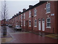
Walsden Street, Clayton, Manchester
An impressively renovated terraced street in the heart of Clayton
Image: © Duncan Watts
Taken: 29 Dec 2011
0.11 miles
7
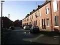
Walsden Street, Clayton, Manchester
A street scene showing older housing typical of this part of Manchester. SJ88209861.
Image: © Keith Williamson
Taken: 28 Sep 2005
0.12 miles
8
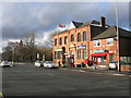
Clayton Conservative Club & Post Office
I have no idea why the flag was being flown at half-mast.
Image: © Peter Whatley
Taken: 24 Jan 2009
0.12 miles
9
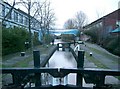
Tram lines on Ashton New Road (A662), Clayton
The Manchester Metrolink extension to Droylsden (and eventually Ashton-under-Lyne) will be street-running along the A662 for 2.5 kilometres (approx 1.5 miles), from Clayton to Droylsden. There will be a further street-running section east of the Droylsden stop, as part of the further extension to Ashton-under-Lyne.
The section of track in this photograph is very near the start of the street-running section in Clayton, and it doesn't presently run for very far. There is a huge amount of further track to be laid, and in early May 2010 just a few further bits of work had been done at various points on the A662. Once the track is laid, then the overhead wiring will have to be installed. The section to Droylsden is due to open in Spring 2012, but the section to Ashton will be later.
Image
Image: © P L Chadwick
Taken: 2 May 2010
0.12 miles
10
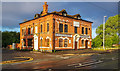
Greens Arms
The Greens Arms was a Wilsons house on the corner of Turner Street and Ashton New Road in Clayton. More recently an Indian restaurant but now closed.
Image: © Peter McDermott
Taken: 2 May 2020
0.12 miles