IMAGES TAKEN NEAR TO
Clayton Street, MANCHESTER, M11 4HT
Introduction
This page details the photographs taken nearby to Clayton Street, M11 4HT by members of the Geograph project.
The Geograph project started in 2005 with the aim of publishing, organising and preserving representative images for every square kilometre of Great Britain, Ireland and the Isle of Man.

There are currently over 7.5m images from over14,400 individuals and you can help contribute to the project by visiting https://www.geograph.org.uk
Image Map
Images are licensed for reuse under creativecommons.org/licenses/by-sa/2.0
Notes
- Clicking on the map will re-center to the selected point.
- The higher the marker number, the further away the image location is from the centre of the postcode.
Image Listing (5 Images Found)
Images are licensed for reuse under creativecommons.org/licenses/by-sa/2.0
Image
Details
Distance
4
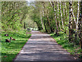
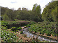
Clayton Vale
One of the main paths through the Clayton Vale Nature Reserve.
Image: © David Dixon
Taken: 1 May 2010
0.25 miles
5
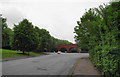
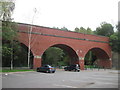
Riverpark Road
The road is enormously wide at this eastern end, and I can only presume that it is to allow abattoir lorries to turn round. The arches opposite are the beginning of Clayton Vale.
Image: © Bill Boaden
Taken: 8 Jun 2010
0.25 miles