IMAGES TAKEN NEAR TO
Pioneer Street, MANCHESTER, M11 4FR
Introduction
This page details the photographs taken nearby to Pioneer Street, M11 4FR by members of the Geograph project.
The Geograph project started in 2005 with the aim of publishing, organising and preserving representative images for every square kilometre of Great Britain, Ireland and the Isle of Man.

There are currently over 7.5m images from over14,400 individuals and you can help contribute to the project by visiting https://www.geograph.org.uk
Image Map
Images are licensed for reuse under creativecommons.org/licenses/by-sa/2.0
Notes
- Clicking on the map will re-center to the selected point.
- The higher the marker number, the further away the image location is from the centre of the postcode.
Image Listing (17 Images Found)
Images are licensed for reuse under creativecommons.org/licenses/by-sa/2.0
Image
Details
Distance
1
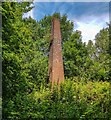
Chimney
The only remains of the Bank Bridge Works and Tannery in Clayton Vale.
Image: © Peter McDermott
Taken: 12 Jul 2020
0.18 miles
3

River Medlock
The River Medlock in its man-made channel in Clayton Vale.
Image: © Peter McDermott
Taken: 12 Jul 2020
0.20 miles
4
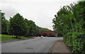
Riverpark Road
The road is enormously wide at this eastern end, and I can only presume that it is to allow abattoir lorries to turn round. The arches opposite are the beginning of Clayton Vale.
Image: © Bill Boaden
Taken: 8 Jun 2010
0.22 miles
6
Ravensbee
Located inside the National Cycling Centre Image, Ravensbee was created by Ravensbury Community School.
Image: © Gerald England
Taken: 24 Aug 2018
0.24 miles
7

50 Nations in 1 School
Located inside the National Cycling Centre Image, 50 Nations in 1 School was created by Whalley Range 11 - 18 High School.
"Whalley Range High School is a true international school within the heart of Manchester. Fifty different languages are spoken within the diverse student population. All who come to Whalley Range are made to feel welcome, to learn and to succeed within the school family. Friendship and learning are key to a tolerant future for all."
Image: © Gerald England
Taken: 24 Aug 2018
0.24 miles
8

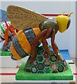
The Beyer/Becker Bee
Located inside the National Cycling Centre Image, The Beyer/Becker Bee was created by Gorton Local History Group.
"Gorton Local History Group decided to base the design of their Bee on two figures from Gorton's history; Beyer Peacock Engineering, based in Gorton 1854-1966, and Lydia Becker, who played a key role in the campaign for women's suffrage and owned the Calico Printers factory on Mount Road."
Image: © Gerald England
Taken: 24 Aug 2018
0.24 miles
9

The Bee from the East
Located inside the National Cycling Centre Image, The Bee from the East was created by 4CT East Manchester Youth Groups.
Image: © Gerald England
Taken: 24 Aug 2018
0.24 miles
10
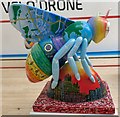
Wright Rob-Bee
Located inside the National Cycling Centre Image, Wright Rob-Bee was created by Wright Robinson College.
The Bee is an amalgamation of over 600 designs exploring themes ranging from Manchester's industrial heritage to students' belief in 'bee-ing themselves'.
Image: © Gerald England
Taken: 24 Aug 2018
0.24 miles