IMAGES TAKEN NEAR TO
Philips Park Road, MANCHESTER, M11 3FX
Introduction
This page details the photographs taken nearby to Philips Park Road, M11 3FX by members of the Geograph project.
The Geograph project started in 2005 with the aim of publishing, organising and preserving representative images for every square kilometre of Great Britain, Ireland and the Isle of Man.

There are currently over 7.5m images from over14,400 individuals and you can help contribute to the project by visiting https://www.geograph.org.uk
Image Map
Images are licensed for reuse under creativecommons.org/licenses/by-sa/2.0
Notes
- Clicking on the map will re-center to the selected point.
- The higher the marker number, the further away the image location is from the centre of the postcode.
Image Listing (124 Images Found)
Images are licensed for reuse under creativecommons.org/licenses/by-sa/2.0
Image
Details
Distance
1
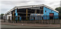
Hall and Rogers
Derelict warehouse.
Image: © Peter McDermott
Taken: 29 Aug 2015
0.04 miles
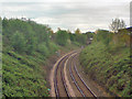
2
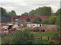
Viaduct
The Cambrian Street Viaduct seen from Ashton New Road. The building work in the foreground is part of the Metrolink extension work.
Image: © David Dixon
Taken: 19 May 2010
0.06 miles
3
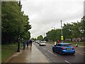
Ashton New Road
Safe walking route from city centre to the Ethiad complex.
Image: © Steve Fareham
Taken: 25 May 2016
0.08 miles
5
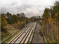
Metrolink East Manchester Extension
The new East Manchester line crossing the River Medlock, just north of Cambrian Street Bridge.
Image: © David Dixon
Taken: 14 Nov 2012
0.09 miles
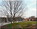
6
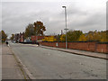
Cambrian Street Bridge
Bridge taking Cambrian Street across the River Medlock and the new Metrolink extension.
The foundation stone (Image]) dates the bridge to 1886 although the brick walls are obviously newer.
Image: © David Dixon
Taken: 14 Nov 2012
0.10 miles
7
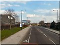
Ashton New Road
The A662 from Manchester to Droylsden approaching Councillor Street (viewed from the top deck of a bus).
Image: © Gerald England
Taken: 1 Mar 2012
0.10 miles
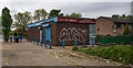
8
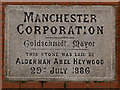
Bridge Plaque, Cambrian Street
Set in the wall of Image
MANCHESTER
CORPORATION
_________________
Goldschmitd Mayor
_________________
THIS STONE WAS LAID BY
ALDERMAN ABEL HEYWOOD
29TH JULY 1886
Image: © David Dixon
Taken: 14 Nov 2012
0.10 miles
10
Holt Town
The Metrolink tram station at Holt Town is under construction. The bridge in the background takes Cambrian Street over the River Medlock.
Image: © Gerald England
Taken: 1 Mar 2012
0.13 miles