IMAGES TAKEN NEAR TO
Spean Walk, MANCHESTER, M11 2HY
Introduction
This page details the photographs taken nearby to Spean Walk, M11 2HY by members of the Geograph project.
The Geograph project started in 2005 with the aim of publishing, organising and preserving representative images for every square kilometre of Great Britain, Ireland and the Isle of Man.

There are currently over 7.5m images from over14,400 individuals and you can help contribute to the project by visiting https://www.geograph.org.uk
Image Map
Images are licensed for reuse under creativecommons.org/licenses/by-sa/2.0
Notes
- Clicking on the map will re-center to the selected point.
- The higher the marker number, the further away the image location is from the centre of the postcode.
Image Listing (52 Images Found)
Images are licensed for reuse under creativecommons.org/licenses/by-sa/2.0
Image
Details
Distance
2
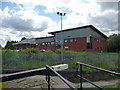
Police Training Unit, Openshaw
Where drivers are trained and vehicles stored. South of Lock 11 on the Ashton Canal.
Image: © Christine Johnstone
Taken: 9 May 2014
0.10 miles
3
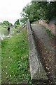
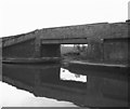
Stub of the former Stockport Branch, Clayton Junction
Looking south from the Ashton Canal towpath bridge.
Image: © Christine Johnstone
Taken: 9 May 2014
0.10 miles
4
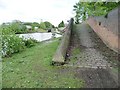
Former canal junction
This is where the Stockport Branch left the Ashton Canal.
Image: © Bill Boaden
Taken: 14 Jun 2010
0.11 miles
5
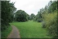
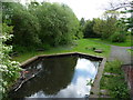
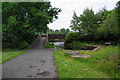
Canalside Open Space in Openshaw
A small "Country Park" by the Ashton Canal.
Image: © Glyn Baker
Taken: 11 Sep 2021
0.11 miles
6
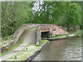
Towpath bridge over the former Stockport Branch
Clayton Junction, between Locks 10 and 11 on the Ashton Canal.
Image: © Christine Johnstone
Taken: 9 May 2014
0.12 miles
7
Towpath Bridge over Side Channel
The side channel now in a small "country park" was only big enough for one narrowboat but is now not navigable.
Image: © Glyn Baker
Taken: 11 Sep 2021
0.12 miles
8
Stockport Branch and Ashton Canal, at Clayton Junction
Compare this with a view taken in 1981 Image
Image: © Christine Johnstone
Taken: 9 May 2014
0.12 miles
9
Site of Clayton Junction
This was the junction where the Stockport Branch led off from the main Ashton Canal, a distance of almost four miles to Stockport in Cheshire. I do not know the official date of closure of this branch, but I suspect it did not see any boats after World War II, although a correspondent recalls that it was still in water at least as far as Gorton until the early 1960s. The branch has now been filled in.
Image: © Dr Neil Clifton
Taken: 12 Apr 1981
0.12 miles
10
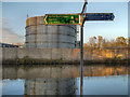
Ashton Canal, Clayton (NCN Route 60)
The Ashton Canal passing the Anchor Chemicals (now a subsidiary of Air Products) factory. Chemicals manufacturing was one of the long established industries in this part of East Manchester.
At this point, the towpath forms part of the National Cycle Network route number 60.
Image: © David Dixon
Taken: 15 Nov 2012
0.12 miles