IMAGES TAKEN NEAR TO
Clayton Lane, MANCHESTER, M11 2FG
Introduction
This page details the photographs taken nearby to Clayton Lane, M11 2FG by members of the Geograph project.
The Geograph project started in 2005 with the aim of publishing, organising and preserving representative images for every square kilometre of Great Britain, Ireland and the Isle of Man.

There are currently over 7.5m images from over14,400 individuals and you can help contribute to the project by visiting https://www.geograph.org.uk
Image Map
Images are licensed for reuse under creativecommons.org/licenses/by-sa/2.0
Notes
- Clicking on the map will re-center to the selected point.
- The higher the marker number, the further away the image location is from the centre of the postcode.
Image Listing (59 Images Found)
Images are licensed for reuse under creativecommons.org/licenses/by-sa/2.0
Image
Details
Distance
1
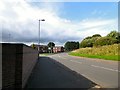
Parkhouse Street
Leading out of West Openshaw into Lower Openshaw and onto Clayton Lane.
Image: © Gerald England
Taken: 28 Sep 2016
0.01 miles
2
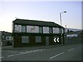
Last Orders!
The Fox Tavern, Clayton Lane, Openshaw. Closed 2003. Situated in a rather neglected area of east Manchester that is now undergoing regeneration on a big scale.
Image: © Keith Williamson
Taken: 2 Sep 2005
0.03 miles
3
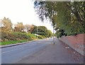
Parkhouse Street
Leading out of Lower Openshaw to West Openshaw.
Image: © Gerald England
Taken: 28 Sep 2016
0.06 miles
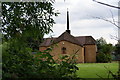
4
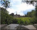
St Barnabas from Parkhouse Street
The original church of St Barnabas in Openshaw dated from 1837. The present church was built in 1961 to replace the original structure which had to be demolished. Constructed of brick, the church has a rectangular nave with short transepts beneath a hipped gull-wing roof. It closed in 2014 when the congregation amalgamated with the Church of the Resurrection http://www.resurrectionstbarnabas.org.uk/about-us/history/ elsewhere in the parish. The burial ground was conveyed to Manchester City Council in 1981. The closed churchyard is now maintained by the local authority as a public open space and some 19th and early 20th century headstones remain in situ.
Image: © Gerald England
Taken: 28 Sep 2016
0.07 miles
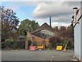
5
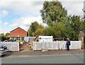
Men's Shed Manchester
This is part of the Openshaw & Beswick Community Garden Food & Farm Project, based at St Barnabas Rectory, Lower Openshaw. https://www.manchestercommunitycentral.org/news/men%E2%80%99s-shed-local-community-project-men-all-ages
Image: © Gerald England
Taken: 28 Sep 2016
0.07 miles
6
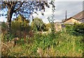
St Barnabas's burial ground
The burial ground at St Barnabas Image
Image: © Gerald England
Taken: 28 Sep 2016
0.08 miles
7
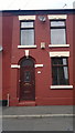
55 Selby Street, Openshaw
55 Selby Street, a red-brick terraced house in the Openshaw area of Manchester, England. Such houses are typical of Greater Manchester.
Image: © Steven Haslington
Taken: 27 Jun 2011
0.09 miles
8
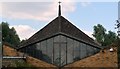
1960s church, South Street, Openshaw
The church is St. Barnabas' and it is located on South Street opposite Dawnay Street in Openshaw. It looks as though it is 1960s modernist style, and it certainly has some interesting geometry if you can see past the razor wire topped wall and the top of the gateposts. This is the best shot I was able to get of this building.
Image: © Bobby Clegg
Taken: 12 Aug 2015
0.09 miles
9
St Barnabas, Openshaw
The original church of St Barnabas in Openshaw dated from 1837. The present church was built in 1961 to replace the original structure which had to be demolished. Constructed of brick, the church has a rectangular nave with short transepts beneath a hipped gull-wing roof. It closed in 2014 when the congregation joined with the Church of the Resurrection http://www.resurrectionstbarnabas.org.uk/about-us/history/ elsewhere in the parish. The burial ground was conveyed to Manchester City Council in 1981. The closed churchyard is now maintained by the local authority as a public open space and some 19th and early 20th century headstones remain in situ.
Image: © Gerald England
Taken: 28 Sep 2016
0.09 miles
10
St Barnabas's Church, Openshaw
This building replaced a cavernous old one, but this one has been up for at least 40 years. It is now difficult to get a shot from this side due to the trees having grown up.
Image: © Bill Boaden
Taken: 14 Jun 2010
0.09 miles