IMAGES TAKEN NEAR TO
Stainburn Road, MANCHESTER, M11 2EB
Introduction
This page details the photographs taken nearby to Stainburn Road, M11 2EB by members of the Geograph project.
The Geograph project started in 2005 with the aim of publishing, organising and preserving representative images for every square kilometre of Great Britain, Ireland and the Isle of Man.

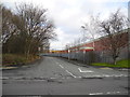
There are currently over 7.5m images from over14,400 individuals and you can help contribute to the project by visiting https://www.geograph.org.uk
Image Map
Images are licensed for reuse under creativecommons.org/licenses/by-sa/2.0
Notes
- Clicking on the map will re-center to the selected point.
- The higher the marker number, the further away the image location is from the centre of the postcode.
Image Listing (18 Images Found)
Images are licensed for reuse under creativecommons.org/licenses/by-sa/2.0
Image
Details
Distance
1
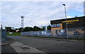
Kelbrook Road, Openshaw
This is a healthy bit of industry, as there is much dereliction not far away.
G H Sheldon make oven-bottom muffins which are readily available in supermarkets locally. The smell of them pervades the locality pleasantly.
Image: © Bill Boaden
Taken: 14 Jun 2010
0.10 miles
2
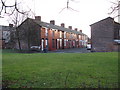
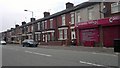
Dunston Street, Openshaw
Part of a section of terraced housing which is now joined to the more modern estate along Greenside Street. Not an area to hang about in.
Image: © Peter Whatley
Taken: 24 Jan 2009
0.14 miles
4
Kelbrooke Road
Off Parkhouse Street.
Image: © Gerald England
Taken: 28 Sep 2016
0.18 miles
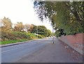
5
Kelbrook Road, Lower Openshaw, Manchester
Leading to Stainburn Road through Parkhouse Street Industrial Estate from Parkhouse Street.
Image: © John Topping
Taken: 31 Jan 2013
0.18 miles
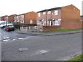
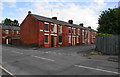
6
Clayton Lane, Openshaw
Terraced properties on Clayton Lane, in the Openshaw area of Manchester, Greater Manchester, England.
Image: © Steven Haslington
Taken: 27 Jun 2011
0.19 miles
7
Boarded-up terraces
Between Parkhouse Street and Ashton Old Road, but it is unlikely that there is any immediate alternative development intended for this area.
Image: © Bill Boaden
Taken: 14 Jun 2010
0.20 miles
8
Parkhouse Street
Leading out of Lower Openshaw to West Openshaw.
Image: © Gerald England
Taken: 28 Sep 2016
0.22 miles
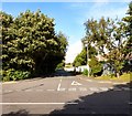
9
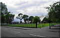
Openshaw Park
The entrance sign is of a design used by Manchester City Council in all their parks. Far left is the Greggs Bakers depot. I think some items are baked there, but others are brought in for distribution.
Image: © Bill Boaden
Taken: 14 Jun 2010
0.22 miles
10
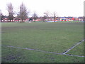
Football Pitch & Playground Off Greenside Street, Openshaw
Image: © Peter Whatley
Taken: 24 Jan 2009
0.23 miles