IMAGES TAKEN NEAR TO
Ashton Old Road, MANCHESTER, M11 1HJ
Introduction
This page details the photographs taken nearby to Ashton Old Road, M11 1HJ by members of the Geograph project.
The Geograph project started in 2005 with the aim of publishing, organising and preserving representative images for every square kilometre of Great Britain, Ireland and the Isle of Man.

There are currently over 7.5m images from over14,400 individuals and you can help contribute to the project by visiting https://www.geograph.org.uk
Image Map
Images are licensed for reuse under creativecommons.org/licenses/by-sa/2.0
Notes
- Clicking on the map will re-center to the selected point.
- The higher the marker number, the further away the image location is from the centre of the postcode.
Image Listing (71 Images Found)
Images are licensed for reuse under creativecommons.org/licenses/by-sa/2.0
Image
Details
Distance
1
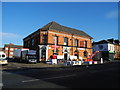
Furniture and Appliance Store
The building (on the corner of Ashton Old Road with Gransmoor Road) was formerly the Gransmoor Hotel (closed in the late 1990s or early 2000s?) and is now a furniture and appliance store.
Image: © John Topping
Taken: 5 Nov 2012
0.05 miles
2
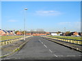
Bowness Street - Higher Openshaw
View north from Toxteth Street.
Image: © John Topping
Taken: 5 Nov 2012
0.05 miles
3
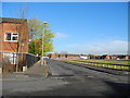
Gransmoor Road - Higher Openshaw
View north from Toxteth Street along Gransmoor Road.
Image: © John Topping
Taken: 5 Nov 2012
0.05 miles
4
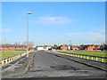
Silverdale Street - Higher Openshaw
View north from Toxteth Street.
Image: © John Topping
Taken: 5 Nov 2012
0.05 miles
5
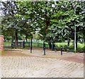
Delamere Park
Delamere Park has a children's play area, Multi use games area (MUGA), bowling greens and free to use tennis courts.
Image: © Gerald England
Taken: 1 Oct 2016
0.06 miles
6
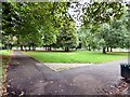
Delamere Park
Delamere Park has a children's play area, Multi use games area (MUGA), bowling greens and free to use tennis courts.
Image: © Gerald England
Taken: 1 Oct 2016
0.07 miles
7
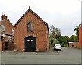
1a Delamere Street
The building on the corner of Delamere Street and Lassell Street looks as if it may once have been a chapel but I haven't found any information about it. Lassell Street leads into Delamere Park.
Image: © Gerald England
Taken: 1 Oct 2016
0.07 miles
8
Cheeryble Street - Higher Openshaw
View north from Toxteth Street.
Image: © John Topping
Taken: 5 Nov 2012
0.07 miles
9
Clement Court ? Adactus Housing Association
Clement Court (sheltered housing) is situated on the corner of Toxteth Street and Cransmoor Road.
Image: © John Topping
Taken: 5 Nov 2012
0.07 miles
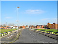
10
Empty Streets ? Higher Openshaw
Waiting for the redevelopment of the Toxteth Street area, from the 2005 East Manchester Redevelopment Plan!
Image: © John Topping
Taken: 5 Nov 2012
0.07 miles