IMAGES TAKEN NEAR TO
Silverlace Avenue, MANCHESTER, M11 1GP
Introduction
This page details the photographs taken nearby to Silverlace Avenue, M11 1GP by members of the Geograph project.
The Geograph project started in 2005 with the aim of publishing, organising and preserving representative images for every square kilometre of Great Britain, Ireland and the Isle of Man.

There are currently over 7.5m images from over14,400 individuals and you can help contribute to the project by visiting https://www.geograph.org.uk
Image Map
Images are licensed for reuse under creativecommons.org/licenses/by-sa/2.0
Notes
- Clicking on the map will re-center to the selected point.
- The higher the marker number, the further away the image location is from the centre of the postcode.
Image Listing (81 Images Found)
Images are licensed for reuse under creativecommons.org/licenses/by-sa/2.0
Image
Details
Distance
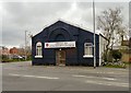
1
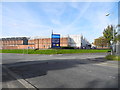
Edge Lane Business Centre, Openshaw - Manchester
At the junction of Fairfield Road and Edge Lane. The works building in the background was part of Ferguson Pailin/AEI/GEC/Alstom until closure.
Image: © John Topping
Taken: 9 Oct 2012
0.06 miles
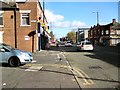
2
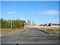
Trevor Street - Higher Openshaw
View north from Toxteth Street.
Image: © John Topping
Taken: 5 Nov 2012
0.07 miles
3
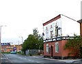
Fairfield Road
On the right hand side is the Bowling Green public house; it is still in use despite its appearance. Further down where the green car can be seen is the junction of Edge Lane and Fairfield Road. The building in the distance used to be an Electrical Engineering works but alas is no more.
Image: © Stephen Burton
Taken: 5 Oct 2005
0.07 miles
4
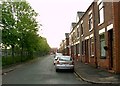
Stopford Street Openshaw
St.Peters school that as now been demolished used to be situated on the left hand side of Stopford Street
Image: © Stephen Burton
Taken: 23 May 2006
0.08 miles
5
Openshaw Community Church
The church on the corner of Toxteth Street and Fairfield Road is the home of the Salvation Army Eden Project. http://web.archive.org/web/20130114035414/http://www.edenopenshaw.org/about/
Image: © Gerald England
Taken: 29 Apr 2013
0.08 miles
6
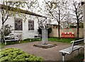
Openshaw Peace Garden
Next to Openshaw Community Church Image is the Eden Openshaw Peace Garden which was developed by Groundwork in partnership with Eden Openshaw and local young people, funded by the New Deal for Communities and the European Regional Development Fund.
Image: © Gerald England
Taken: 29 Apr 2013
0.09 miles
7
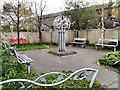
Openshaw Peace Garden
Next to Openshaw Community Church Image is the Eden Openshaw Peace Garden which was developed by Groundwork in partnership with Eden Openshaw and local young people, funded by the New Deal for Communities and the European Regional Development Fund.
Image: © Gerald England
Taken: 29 Apr 2013
0.09 miles
8
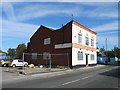
Refurbishing an ex pub, Fairfield Road - Droylsden
Formerly the Bowling Green, the property is now to let.
Image: © John Topping
Taken: 9 Oct 2012
0.09 miles
9
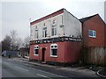
The Bowling Green pub, Fairfield Road, Droylsden
Derelict pub in the back streets of Droyslden, Tameside.
Image: © Duncan Watts
Taken: 6 Jan 2011
0.09 miles
10
Ashton Old Road
The A635 towards Ashton under Lyne from the corner of Beck Street.
Image: © Gerald England
Taken: 22 Oct 2018
0.10 miles