IMAGES TAKEN NEAR TO
Burman Street, MANCHESTER, M11 1EY
Introduction
This page details the photographs taken nearby to Burman Street, M11 1EY by members of the Geograph project.
The Geograph project started in 2005 with the aim of publishing, organising and preserving representative images for every square kilometre of Great Britain, Ireland and the Isle of Man.

There are currently over 7.5m images from over14,400 individuals and you can help contribute to the project by visiting https://www.geograph.org.uk
Image Map
Images are licensed for reuse under creativecommons.org/licenses/by-sa/2.0
Notes
- Clicking on the map will re-center to the selected point.
- The higher the marker number, the further away the image location is from the centre of the postcode.
Image Listing (89 Images Found)
Images are licensed for reuse under creativecommons.org/licenses/by-sa/2.0
Image
Details
Distance
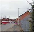
1
Burman Street - Higher Openshaw
View northeast from Toxteth Street.
Image: © John Topping
Taken: 5 Nov 2012
0.02 miles
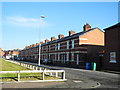
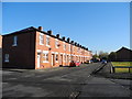
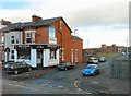
2
Burman Street
Looking up Burman Street, Openshaw. The row of terraced housing on the right have been renovated in recent years. On the left, though, whole streets have been totally demolished and now new housing is being built on the land.
Image: © Gerald England
Taken: 1 Oct 2016
0.03 miles
3
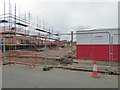
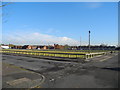
New housing in Openshaw
Several streets north of Toxteth Street were demolished in recent years. Now new housing is being built on the site.
Image: © Gerald England
Taken: 1 Oct 2016
0.03 miles
4
Ambush Street - Higher Openshaw
View north from Toxteth Street.
Image: © John Topping
Taken: 5 Nov 2012
0.03 miles
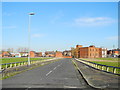
5
Toxteth Street - Higher Openshaw
View of the east end of Toxteth Street from the junction with Burman Street.
Image: © John Topping
Taken: 5 Nov 2012
0.04 miles
6
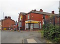
Westwell's Bakery
Westwell's Bakery on Peel Street was opened in 1952 by Arthur Westwell. Arthur had been helping out in his Aunty's shop, Blacks in Droylsden, from the age of 10. At 22 he opened his first shop on Ashton Old Road before moving to Peel Street. When Arthur retired in 1990 the business was taken over by Kevin Rutter and his wife Debbie. Kevin had started working there as a Saturday boy in 1972. http://web.archive.org/web/20161013100311/http://westwellsbakery.co.uk/aboutus.htm
Image: © Gerald England
Taken: 1 Oct 2016
0.06 miles
7
Cheeryble Street - Higher Openshaw
View north from Toxteth Street.
Image: © John Topping
Taken: 5 Nov 2012
0.06 miles
8
Justlife Health & Enterprise Centre
The Justlife centre on Ashton Old Road describes itself:
"The Justlife Health & Enterprise Centre is based in Openshaw, East Manchester, at the heart of a dense area of temporary accommodation, hostels, B&Bs, houses of multiple occupancy, bedsits and similar low-grade accommodation. Being situated on the doorstep of some of the most vulnerable and hard-to-reach people in the city enables us to engage with, support and move on people with multiple and critical needs.
The Centre provides a radical welcome to anyone who accesses our service. Taking an aspirational approach, the provision of a friendly morning drop in and weekly meals act as a means of encouraging greater engagement in our workshop programme and project work which in turn help to build build relationships, self-confidence, skills and experience. This ultimately will enable people to make a positive contribution to society through volunteering, employment or enterprise creation. The primary funder of the centre is the Big Lottery Fund, who has supported the centre since opening January 2010."
Website: https://www.justlife.org.uk/projects/justlife-manchester/
Note: The photograph is for record purposes only. The photographer was no personal connection with the centre.
Image: © Gerald England
Taken: 1 Oct 2016
0.07 miles
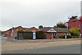
9
Deb 'n' Hair
Hairdressers at the corner of Ashton Old Road and Burman Street, Higher Openshaw.
Image: © Gerald England
Taken: 28 Nov 2012
0.07 miles
10
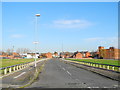
Empty Streets ? Higher Openshaw
Waiting for the redevelopment of the Toxteth Street area, from the 2005 East Manchester Redevelopment Plan!
Image: © John Topping
Taken: 5 Nov 2012
0.08 miles