IMAGES TAKEN NEAR TO
Fairfield Road, MANCHESTER, M11 1EW
Introduction
This page details the photographs taken nearby to Fairfield Road, M11 1EW by members of the Geograph project.
The Geograph project started in 2005 with the aim of publishing, organising and preserving representative images for every square kilometre of Great Britain, Ireland and the Isle of Man.

There are currently over 7.5m images from over14,400 individuals and you can help contribute to the project by visiting https://www.geograph.org.uk
Image Map
Images are licensed for reuse under creativecommons.org/licenses/by-sa/2.0
Notes
- Clicking on the map will re-center to the selected point.
- The higher the marker number, the further away the image location is from the centre of the postcode.
Image Listing (71 Images Found)
Images are licensed for reuse under creativecommons.org/licenses/by-sa/2.0
Image
Details
Distance
1
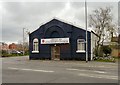
Openshaw Community Church
The church on the corner of Toxteth Street and Fairfield Road is the home of the Salvation Army Eden Project. http://web.archive.org/web/20130114035414/http://www.edenopenshaw.org/about/
Image: © Gerald England
Taken: 29 Apr 2013
0.05 miles
2
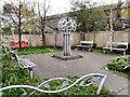
Openshaw Peace Garden
Next to Openshaw Community Church Image is the Eden Openshaw Peace Garden which was developed by Groundwork in partnership with Eden Openshaw and local young people, funded by the New Deal for Communities and the European Regional Development Fund.
Image: © Gerald England
Taken: 29 Apr 2013
0.05 miles
3
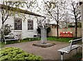
Openshaw Peace Garden
Next to Openshaw Community Church Image is the Eden Openshaw Peace Garden which was developed by Groundwork in partnership with Eden Openshaw and local young people, funded by the New Deal for Communities and the European Regional Development Fund.
Image: © Gerald England
Taken: 29 Apr 2013
0.05 miles
4
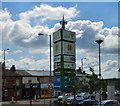
Signage at Lime Square
At the edge of Lime Square in Openshaw a large sign advertises the businesses that occupy the site.
Image: © Gerald England
Taken: 25 Jun 2016
0.06 miles
5
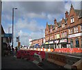
Roadworks on Ashton Old Road
The A635 through Openshaw.
Image: © Gerald England
Taken: 27 Mar 2021
0.07 miles
6
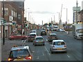
Higher Openshaw
The A635 from Ashton under Lyne to Manchester at its junction with Ogden Lane/Fairfield Road. In the background is the Beetham Tower Image in Image
Image: © Gerald England
Taken: 28 Nov 2012
0.07 miles
7
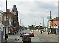
Centre of Openshaw
The A635 Ashton Old Road passes through the centre of Openshaw.
Image: © Gerald England
Taken: 13 Jun 2015
0.07 miles
8
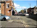
Ashton Old Road
The A635 towards Ashton under Lyne from the corner of Beck Street.
Image: © Gerald England
Taken: 22 Oct 2018
0.07 miles
9
Stopford Street Openshaw
St.Peters school that as now been demolished used to be situated on the left hand side of Stopford Street
Image: © Stephen Burton
Taken: 23 May 2006
0.08 miles
10
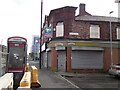
Corner of Ashton Old Road and Swindells Street
In 2008 the business on the corner was The Village Cafe. Between June 2017 and May 2018 it had changed to become Donnelley's Fish & Chip shop but that seems now to be permanently closed.
Image: © Gerald England
Taken: 27 Mar 2021
0.08 miles