IMAGES TAKEN NEAR TO
Dunstable Road, LEIGHTON BUZZARD, LU7 9ST
Introduction
This page details the photographs taken nearby to Dunstable Road, LU7 9ST by members of the Geograph project.
The Geograph project started in 2005 with the aim of publishing, organising and preserving representative images for every square kilometre of Great Britain, Ireland and the Isle of Man.

There are currently over 7.5m images from over14,400 individuals and you can help contribute to the project by visiting https://www.geograph.org.uk
Image Map
Images are licensed for reuse under creativecommons.org/licenses/by-sa/2.0
Notes
- Clicking on the map will re-center to the selected point.
- The higher the marker number, the further away the image location is from the centre of the postcode.
Image Listing (7 Images Found)
Images are licensed for reuse under creativecommons.org/licenses/by-sa/2.0
Image
Details
Distance
1
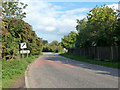
Dunstable Road leaves Tilsworth
Heading not directly towards Dunstable, but to the A5, which does.
Image: © Robin Webster
Taken: 19 Sep 2015
0.12 miles
2

Tilsworth from the air
Under a thin blanket of mist, as viewed from a Glasgow bound flight from Luton.
Image: © Thomas Nugent
Taken: 13 Oct 2012
0.14 miles
3
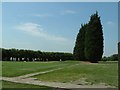
Tilsworth Golf Course
I think the ladies pictured are practising their pitching by the looks of it.
Image: © Rob Farrow
Taken: 29 Jun 2006
0.16 miles
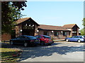
4
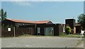
Tilsworth Golf Centre : The Clubhouse
Tilsworth Golf Centre has an 18-hole golf course and a driving range open to non-members. See http://www.tilsworthgolf.co.uk/ for more details.
Image: © Rob Farrow
Taken: 29 Jun 2006
0.16 miles
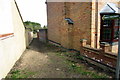
5
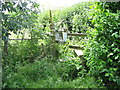
Hidden stile
Saw this when playing golf at Tilsworth. Notice gives details of Diversion of parts of Tilsworth Footpath No 7.
Image: © Malcolm Campbell
Taken: 3 Jul 2010
0.17 miles