IMAGES TAKEN NEAR TO
Treachers Close, LEIGHTON BUZZARD, LU7 9SR
Introduction
This page details the photographs taken nearby to Treachers Close, LU7 9SR by members of the Geograph project.
The Geograph project started in 2005 with the aim of publishing, organising and preserving representative images for every square kilometre of Great Britain, Ireland and the Isle of Man.

There are currently over 7.5m images from over14,400 individuals and you can help contribute to the project by visiting https://www.geograph.org.uk
Image Map
Images are licensed for reuse under creativecommons.org/licenses/by-sa/2.0
Notes
- Clicking on the map will re-center to the selected point.
- The higher the marker number, the further away the image location is from the centre of the postcode.
Image Listing (29 Images Found)
Images are licensed for reuse under creativecommons.org/licenses/by-sa/2.0
Image
Details
Distance
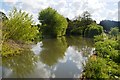
2
The Mill Pond, Ford End, Ivinghoe
The mill pond is fed by the Whistle Brook which, in former times, had already worked Brookend Mill (now a private house).
For more information see Image
Image: © Chris Reynolds
Taken: 13 Apr 2009
0.19 miles
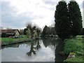
3
Ford End Farm at Ivinghoe
This is still a working farm, but is more widely known because of the watermill Image
Image: © Chris Reynolds
Taken: 13 Apr 2009
0.21 miles
4
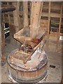
The Hopper and Mill Stone of the Watermill at Ford End, Ivinghoe
These are on the Stone Floor. Grain comes from a bin on the top (Bin) floor into the hopper, from which it is fed into the centre of the stones, which are cased.
For more information see Image
Image: © Chris Reynolds
Taken: 13 Apr 2009
0.22 miles
5
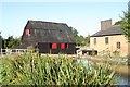
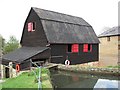
Ford End watermill, Ivinghoe
The watermill seen over the mill pond
Image: © Jim Woodward-Nutt
Taken: 8 Sep 2006
0.22 miles
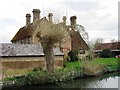
6
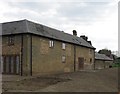
Bull Pen, Ford End Farm, Ivinghoe
This farm barn has recently be converted to self-catering holiday accommodation.
Image: © Chris Reynolds
Taken: 13 Apr 2009
0.23 miles
8
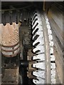
The Pit Wheel and Main Shaft of the Watermill at Ford End, Ivinghoe
The pit wheel turns with the waterwheel and the cogs engage with the main shaft, which directly turns the mill stone.
For more information see Image
Image: © Chris Reynolds
Taken: 13 Apr 2009
0.23 miles
9
Ford End Water Mill, Ivinghoe, from by the Mill Pond
The external appearance of the mill has changed over the years. For instance in the early 19th century it had a peg-tiled roof – and the wheel was open.
For more information see Image
Image: © Chris Reynolds
Taken: 13 Apr 2009
0.23 miles
10
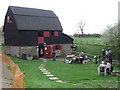
Ford End Watermill, Ivinghoe, from the North
See Image for general information about the mill.
This picture was taken on one of the open days. The Mill Race is in the ditch surrounded by the wooden fence, and crossed by the footbridge. The paved area beyond the table, and the black spout sticking out of the wall at the far right of the building, are connected with the sheep wash Image .
Image: © Chris Reynolds
Taken: 13 Apr 2009
0.23 miles