IMAGES TAKEN NEAR TO
Church End, LEIGHTON BUZZARD, LU7 9NJ
Introduction
This page details the photographs taken nearby to Church End, LU7 9NJ by members of the Geograph project.
The Geograph project started in 2005 with the aim of publishing, organising and preserving representative images for every square kilometre of Great Britain, Ireland and the Isle of Man.

There are currently over 7.5m images from over14,400 individuals and you can help contribute to the project by visiting https://www.geograph.org.uk
Image Map
Images are licensed for reuse under creativecommons.org/licenses/by-sa/2.0
Notes
- Clicking on the map will re-center to the selected point.
- The higher the marker number, the further away the image location is from the centre of the postcode.
Image Listing (23 Images Found)
Images are licensed for reuse under creativecommons.org/licenses/by-sa/2.0
Image
Details
Distance
1
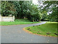
Approaching a postbox in Church End, Hockliffe
Image: © Basher Eyre
Taken: 6 Sep 2011
0.03 miles
2
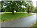
Grass triangle opposite the parish church
Image: © Basher Eyre
Taken: 6 Sep 2011
0.04 miles
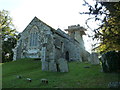
3
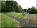
St. Nicholas, Church End, Hockliffe: church path (b)
Image: © Basher Eyre
Taken: 6 Sep 2011
0.04 miles
4
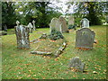
Gravestones in the churchyard at St Nicholas, Hockliffe
Image: © Basher Eyre
Taken: 6 Sep 2011
0.05 miles
6
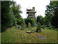
Scaffolding on the tower at St Nicholas, Hockliffe
Image: © Basher Eyre
Taken: 6 Sep 2011
0.05 miles
7
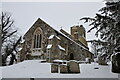
St. Nicholas Church in the snow
St. Nicholas Church, Hockliffe in the snow on an early February morning
Image: © Bob Walters
Taken: 5 Feb 2012
0.05 miles
9
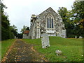
St. Nicholas, Church End, Hockliffe: church path (c)
Image: © Basher Eyre
Taken: 6 Sep 2011
0.05 miles
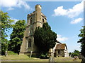
10
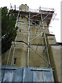
Repairs unddrway at St. Nicholas, Church End, Hockliffe
Image: © Basher Eyre
Taken: 6 Sep 2011
0.05 miles