IMAGES TAKEN NEAR TO
Heath and Reach, LEIGHTON BUZZARD, LU7 9LD
Introduction
This page details the photographs taken nearby to LU7 9LD by members of the Geograph project.
The Geograph project started in 2005 with the aim of publishing, organising and preserving representative images for every square kilometre of Great Britain, Ireland and the Isle of Man.

There are currently over 7.5m images from over14,400 individuals and you can help contribute to the project by visiting https://www.geograph.org.uk
Image Map
Images are licensed for reuse under creativecommons.org/licenses/by-sa/2.0
Notes
- Clicking on the map will re-center to the selected point.
- The higher the marker number, the further away the image location is from the centre of the postcode.
Image Listing (5 Images Found)
Images are licensed for reuse under creativecommons.org/licenses/by-sa/2.0
Image
Details
Distance
2
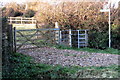
Overgreen End Public Footpath
A short footpath that heads towards the site of an ancient settlement (information courtesy of the sign on the right of the picture).
Image: © Mr Biz
Taken: 20 May 2008
0.10 miles
5
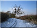
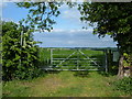
Heath and Reach: Near Overendgreen Farm
The lane between Heath and Reach and Overendgreen Farm viewed looking westwards with a light covering of snow on the ground.
Image: © Nigel Cox
Taken: 28 Dec 2005
0.18 miles