IMAGES TAKEN NEAR TO
Corfe Road, LEIGHTON BUZZARD, LU7 9FY
Introduction
This page details the photographs taken nearby to Corfe Road, LU7 9FY by members of the Geograph project.
The Geograph project started in 2005 with the aim of publishing, organising and preserving representative images for every square kilometre of Great Britain, Ireland and the Isle of Man.

There are currently over 7.5m images from over14,400 individuals and you can help contribute to the project by visiting https://www.geograph.org.uk
Image Map
Images are licensed for reuse under creativecommons.org/licenses/by-sa/2.0
Notes
- Clicking on the map will re-center to the selected point.
- The higher the marker number, the further away the image location is from the centre of the postcode.
Image Listing (15 Images Found)
Images are licensed for reuse under creativecommons.org/licenses/by-sa/2.0
Image
Details
Distance
1
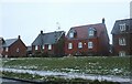
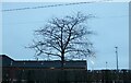
New houses on Westfield Road, Pitstone
Image: © David Howard
Taken: 18 Dec 2022
0.14 miles
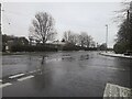
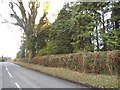
2
Lower Icknield Way, Pitstone
Overlooking the sports ground
Image: © David Howard
Taken: 31 Dec 2017
0.15 miles
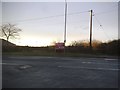
3
Marsworth Road at the junction of Westfield Road
Opposite the electricity substation.
Image: © David Howard
Taken: 18 Dec 2022
0.15 miles
4

Pitstone chalk pits from the air
On approach to Luton Airport from the south.
Image: © Thomas Nugent
Taken: 29 Mar 2013
0.15 miles
5
Lower Icknield Way at the corner of Westfield Road
Image: © David Howard
Taken: 31 Dec 2017
0.15 miles
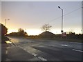
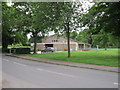
6
Pitstone Skatepark
On Lower Icknield Way
Image: © David Howard
Taken: 18 Dec 2022
0.16 miles
7
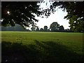
Pitstone village green and cricket pitch
Image: © Jeff Tomlinson
Taken: 27 Sep 2008
0.18 miles
10
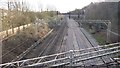
West Coast Main Line
From the B489 Bridge the West Coast Main Line
Image: © Shaun Ferguson
Taken: 17 Jan 2020
0.21 miles