IMAGES TAKEN NEAR TO
Hartop Close, LEIGHTON BUZZARD, LU7 9FR
Introduction
This page details the photographs taken nearby to Hartop Close, LU7 9FR by members of the Geograph project.
The Geograph project started in 2005 with the aim of publishing, organising and preserving representative images for every square kilometre of Great Britain, Ireland and the Isle of Man.

There are currently over 7.5m images from over14,400 individuals and you can help contribute to the project by visiting https://www.geograph.org.uk
Image Map
Images are licensed for reuse under creativecommons.org/licenses/by-sa/2.0
Notes
- Clicking on the map will re-center to the selected point.
- The higher the marker number, the further away the image location is from the centre of the postcode.
Image Listing (5 Images Found)
Images are licensed for reuse under creativecommons.org/licenses/by-sa/2.0
Image
Details
Distance
1
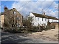
Hope Cottages
A group of cottages next to Willow Farm on the road from Ivinghoe Aston to Slapton, looking North West
Image: © Chris Cole
Taken: 4 Mar 2006
0.04 miles
2
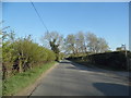
Chapel Lane
The road to Ivinghoe Aston
Image: © David Howard
Taken: 23 Apr 2015
0.15 miles
3
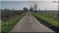
Path up to Grove Farm
Path and drive up to Grove Farm
Image: © Shaun Ferguson
Taken: 30 Mar 2021
0.16 miles

5

Water filled channel in Ivinghoe Aston
Quite wide and quite full.
Image: © Jeremy Bolwell
Taken: 16 Jan 2022
0.21 miles