IMAGES TAKEN NEAR TO
Palmer Crescent, LEIGHTON BUZZARD, LU7 4HT
Introduction
This page details the photographs taken nearby to Palmer Crescent, LU7 4HT by members of the Geograph project.
The Geograph project started in 2005 with the aim of publishing, organising and preserving representative images for every square kilometre of Great Britain, Ireland and the Isle of Man.

There are currently over 7.5m images from over14,400 individuals and you can help contribute to the project by visiting https://www.geograph.org.uk
Image Map
Images are licensed for reuse under creativecommons.org/licenses/by-sa/2.0
Notes
- Clicking on the map will re-center to the selected point.
- The higher the marker number, the further away the image location is from the centre of the postcode.
Image Listing (4 Images Found)
Images are licensed for reuse under creativecommons.org/licenses/by-sa/2.0
Image
Details
Distance
2

Leighton Buzzard from the air
The former RAF Stanbridge running track can be seen near the centre of the photo which was taken from a Glasgow bound flight from Luton.
Image: © Thomas Nugent
Taken: 13 Oct 2012
0.21 miles
4
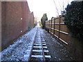
Leighton Buzzard: Narrow gauge railway
A light dusting of snow covers the railway sleepers in this view taken looking southwards towards the Page's Park terminus from the Stanbridge Road level crossing. Residential properties and factories have been built up to the line here where it used to run in open countryside. The very informative Leighton Buzzard Railway website can be found here http://www.buzzrail.co.uk/
Image: © Nigel Cox
Taken: 28 Dec 2005
0.25 miles