IMAGES TAKEN NEAR TO
Grovebury Farm Close, LEIGHTON BUZZARD, LU7 4EQ
Introduction
This page details the photographs taken nearby to Grovebury Farm Close, LU7 4EQ by members of the Geograph project.
The Geograph project started in 2005 with the aim of publishing, organising and preserving representative images for every square kilometre of Great Britain, Ireland and the Isle of Man.

There are currently over 7.5m images from over14,400 individuals and you can help contribute to the project by visiting https://www.geograph.org.uk
Image Map
Images are licensed for reuse under creativecommons.org/licenses/by-sa/2.0
Notes
- Clicking on the map will re-center to the selected point.
- The higher the marker number, the further away the image location is from the centre of the postcode.
Image Listing (7 Images Found)
Images are licensed for reuse under creativecommons.org/licenses/by-sa/2.0
Image
Details
Distance
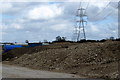
3
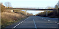
Bridge over A4146, Leighton Buzzard
A footpath crosses.
Image: © Robin Webster
Taken: 8 Dec 2019
0.15 miles
6
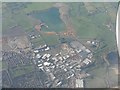
0741 Looking south from over Leighton Buzzard
The A505 crosses the picture between the industrial estate and the flooded sand pit to the south. The thin winding line to the right is the Grand Union Canal.
Image: © M J Richardson
Taken: 21 Apr 2010
0.20 miles
7
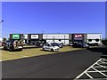
Grovebury Retail Park in Leighton Buzzard
Image: © Steve Daniels
Taken: 14 Sep 2020
0.25 miles