IMAGES TAKEN NEAR TO
Cruickshank Mead, LEIGHTON BUZZARD, LU7 4EE
Introduction
This page details the photographs taken nearby to Cruickshank Mead, LU7 4EE by members of the Geograph project.
The Geograph project started in 2005 with the aim of publishing, organising and preserving representative images for every square kilometre of Great Britain, Ireland and the Isle of Man.

There are currently over 7.5m images from over14,400 individuals and you can help contribute to the project by visiting https://www.geograph.org.uk
Image Map
Images are licensed for reuse under creativecommons.org/licenses/by-sa/2.0
Notes
- Clicking on the map will re-center to the selected point.
- The higher the marker number, the further away the image location is from the centre of the postcode.
Image Listing (4 Images Found)
Images are licensed for reuse under creativecommons.org/licenses/by-sa/2.0
Image
Details
Distance
2
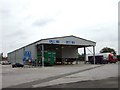
Vehicle Testing Station
This Department of Transport Vehicle Testing Station is just to the east of Leighton Buzzard and seems to specialise in testing lorries. It looked to be doing brisk business when I took this shot.
Image: © Rob Farrow
Taken: 15 Aug 2006
0.13 miles
3
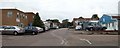
Industrial Estate, Leighton Buzzard
This Industrial Estate is on the northern side of the road to Stanbridge out of Leighton Buzzard.
Image: © Rob Farrow
Taken: 15 Aug 2006
0.17 miles