IMAGES TAKEN NEAR TO
Osprey Drive, LEIGHTON BUZZARD, LU7 4BW
Introduction
This page details the photographs taken nearby to Osprey Drive, LU7 4BW by members of the Geograph project.
The Geograph project started in 2005 with the aim of publishing, organising and preserving representative images for every square kilometre of Great Britain, Ireland and the Isle of Man.

There are currently over 7.5m images from over14,400 individuals and you can help contribute to the project by visiting https://www.geograph.org.uk
Image Map
Images are licensed for reuse under creativecommons.org/licenses/by-sa/2.0
Notes
- Clicking on the map will re-center to the selected point.
- The higher the marker number, the further away the image location is from the centre of the postcode.
Image Listing (3 Images Found)
Images are licensed for reuse under creativecommons.org/licenses/by-sa/2.0
Image
Details
Distance
2
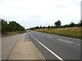
A505 and lay-by
There are few features in this square which is dominated by the comparatively new A505. This lay-by regularly has a fast-food van providing victuals for passing motorists - or rather for those that stop !
Image: © Rob Farrow
Taken: 15 Aug 2006
0.22 miles
3
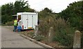
Fast Food
A little mobile café in a layby on the busy A505 near Leighton Buzzard.
Image: © Rob Farrow
Taken: 15 Aug 2006
0.22 miles