IMAGES TAKEN NEAR TO
Plantation Road, LEIGHTON BUZZARD, LU7 3HR
Introduction
This page details the photographs taken nearby to Plantation Road, LU7 3HR by members of the Geograph project.
The Geograph project started in 2005 with the aim of publishing, organising and preserving representative images for every square kilometre of Great Britain, Ireland and the Isle of Man.

There are currently over 7.5m images from over14,400 individuals and you can help contribute to the project by visiting https://www.geograph.org.uk
Image Map
Images are licensed for reuse under creativecommons.org/licenses/by-sa/2.0
Notes
- Clicking on the map will re-center to the selected point.
- The higher the marker number, the further away the image location is from the centre of the postcode.
Image Listing (22 Images Found)
Images are licensed for reuse under creativecommons.org/licenses/by-sa/2.0
Image
Details
Distance
7
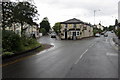
Bus stop and sheltered housing on Heath Road
Image: © Philip Jeffrey
Taken: 15 Jun 2013
0.16 miles
8
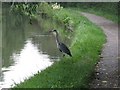
Heron seeking breakfast
On the Grand Union Canal just north of Linslade.
Image: © M J Richardson
Taken: 6 Sep 2008
0.20 miles
9
![Leighton Lock [no. 27] - Grand Union Canal](https://s3.geograph.org.uk/photos/95/66/956603_553e5357_120x120.jpg)
Leighton Lock [no. 27] - Grand Union Canal
Image: © M J Richardson
Taken: 6 Sep 2008
0.21 miles
10
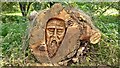
Tree trunk carving
Walkers on the canal towpath are greeted by this impressive carving in the trunk of a fallen tree.
Image: © Mark Percy
Taken: 9 Oct 2021
0.22 miles